| ID |
Type |
Name |
Description |
Photo |
| 1 | recreation area | Área recreativa El Termet | <p>A u ... <p>A unique environment rich in biodiversity that runs along the banks of the Mijares River. This is our protected landscape of the Termet, a true lung and a haven of vegetation. We recommend a quiet walk along the botanical path. The path follows the route of the old Mayor irrigation channel and the course of the Mijares river. It is a tour suitable for all ages. The leafy shade vegetation has been collected by the botanist from Vila Real, Manuel Calduch, who has bequeathed an important botanical compendium recognized by UNESCO. Do not forget to contemplate the Santa Quiteria bridge, ordered to be built by King Jaime I. Next to the botanical route, you can visit the Hermitage of the Mare de Déu de Gràcia and the cave in which the image of the Virgin of Gràcia was discovered. Funny.<br></p> | 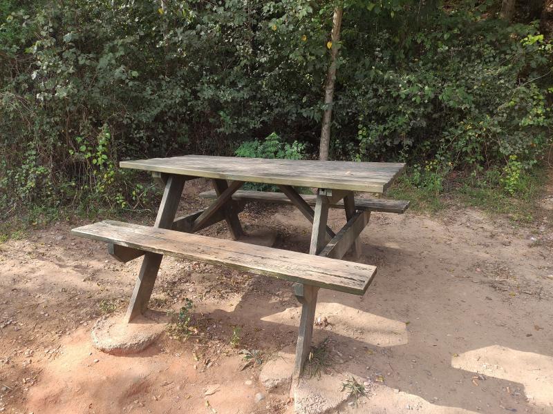 |
| 2 | weir | Azud de Vila-Real | <p>Mil ... <p>Millars water distribution area, for Vila-real, Burriana, Almassora and Castelló irrigators.<br></p><p>It is the main element of the hydraulic architecture of the Community, the starting point of the entire complex system of ditches and brazales that complete the necessary infrastructure for the movement of water throughout the garden. Its function is to raise the water to ensure the feeding of the Acequia. It is located on the right bank of the Mijares river some two hundred meters above the Hermitage of the Virgen de Gracia, and at a level slightly higher than 50 meters. It is built with ashlar masonry and mortar in a narrowing of the river just at the beginning of the meander and taking advantage of its concave part. The dam or Azud, properly speaking, consists of three walls intertwined by large buttresses that fragment a possible large arch.<br></p><p>Located near or rather under the Termet bridge. A beautiful place and at the same time dangerous, since there are strong currents and they can put more than one person in trouble, if they decide to swim in this area.</p><p><img src="https://www.regvila.com/uploads/paginas/093355_assut1-rd.jpg" alt="El Assut"><strong><br></strong></p><p><strong>History</strong><br></p><p>The first weirs are of Roman origin, but it was the Arabs and their settlement who promoted this type of work. The first written documentation dates back to 1307, when it was then a weir made of wood and logs.</p><p>In 1468 the municipal council agreed to build the first weir of mortar and ashlars in part and the rest continued to be made of logs and wood.</p><p>After a great flood, it was built on a new floor, probably already then entirely made of stone.</p><p>New works in 1581 being the predecessor of the current one.<br></p><p><strong>Current Weir</strong><br></p><p>On June 10, 1886, construction work began on the new dam, which was completed in 1895, giving it the shape and appearance it has today; The dam is made of carved masonry and is 106 meters long.</p><p>During the 20th century, an important reconstruction was carried out in 1929.</p><p><strong>Splitters</strong>.<br></p><p>As a result of the Arbitral Sentence of 1347, which distributed the amount of water from the river in rows for the four towns of La Plana, the point of division and calculation was set at the Vila-real Dam.<br></p><p><strong>Mined ditch</strong><br></p><p>The continuous flooding of the river caused the bed of the old ditch -which circulated along the river (séquia de les Argamasses)- to be covered and destroyed by the materials of the avenues, which is why in 1869 another route was planned -which crosses the Termet area underground- and that at the time, as is easy to think, was a major project in which the entire population participated.<br></p> | 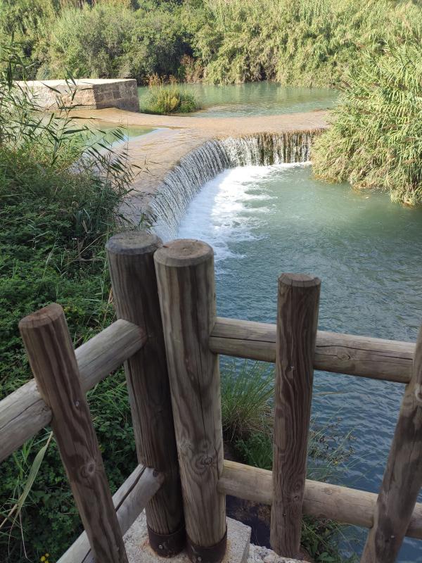 |
| 3 | water well | Museo Universitario MUA | <p&g ... <p>Este magnífico edificio es uno de los más elogiados a nivel internacional de los existentes en el campus de la Universidad de Alicante, y nace como resultado de un concurso de arquitectura ganado por el arquitecto Alfredo Payá Beneyto. El museo se sitúa en el extremo del campus universitario, cerca de la autovía. Su imagen es espectacular, rotunda, elegante y delicada, al tiempo que inaccesible: una gran caja de madera flota en el vacío. Esta caja alberga la sala principal del museo y se sitúa en la parte central de un gran vacío excavado. Alrededor existe un estanque artificial sobre el que se refleja la caja de madera creando el efecto de ingravidez. Bajo el estanque se desarrolla el resto de salas y programa del museo.</p><p><img src="data:image/jpeg;base64,/9j/4AAQSkZJRgABAQAAAQABAAD/2wCEAAoHCBISERIREhUYGBgZGBgYGBgaGBIYGBgYGBgZGRgYGBkcIS4lHB4rIRgYJjgmKy8xNTU1GiQ7QDs0Py40NTEBDAwMEA8QGhISHDQrJCs0NDQ0NDQ2NDQ0NDQ0NjE0NDQ0NDY1NTE0NDQ0NDQ0NDQ0NDQxMTQ0NDQ0NDQ0NDE0NP/AABEIALcBEwMBIgACEQEDEQH/xAAbAAACAwEBAQAAAAAAAAAAAAAABAECAwUGB//EAEIQAAEDAgMEBgUJBwQDAAAAAAEAAhEDEgQTIQYxQVEFImFxgbEUMpGhwSNCYnKCwtHS8DNSY5KisvEHFRZEF4PT/8QAGQEBAQEBAQEAAAAAAAAAAAAAAAECAwQF/8QALREBAAICAQMDAwEJAQAAAAAAAAERAhIDEzFRBCFBFJGh8QUiIzJSYYHR8BX/2gAMAwEAAhEDEQA/APbEKpCuQohfSt4lIUQtIUQlikKIVyFEJaKwhTCIVFbVUtWkIlBkQohaQiEtKZQiFpaohLRmWohbA81UtS1pnCiFeFEK2isIhWhEJYpCIV4RCWKQiFeEQlisIhWhEJaqwiFaEQliIRCmFMKWKwiFaFMIqsKQFMKYRUQhWhCBuFEK8KIXO1pSFELSEWpZTKEQtbVBarZTKFELW1RallMoRC0hEK2lMoRCvai1LSlCFEK9qC1WymcIWlqLUsUUWq0IhLFIRCvCISymcIhaQohLKUhEK8IhLKUhEK8IhLKUhEK8IhLWlIUwrwiEsUhEK8IhSxWEQrQphLWlYQrQhLKOwotWtqIXK2qZ2qIWlqISxnCqWraFFqWjG1Fq2tUQllMrVFq2hRaraUytUQtrVFqWUyhRatbUWpsUytUWra1RarZTK1RatrVFqWUytUWra1FqWUwtRatrVEJZTG1Fq2hRamxTK1ELW1RallM4RCvai1LVSEQr2ohLSlIUwrQphS1pSFMK0IhLKVhCvCEso9CIV4RC47OlKQi1XhEJsUztRatIRCuyUztUWrSEQmxTO1RatIRCWUztRatIRCWas7VFq1hRCbFM7UWrS1FqbJqytRatLUWpZqyhRatbVFqbGrK1RatrUWpZTG1RatrVFqbGrGEQtbFFqbFM7UWrS1RarstMoRC0hRCmxSkIhWhEK7FKwiFaEQpZSsIVoQmxR5ErJ9djbpPqxdzE7p5LLC46nUdUYwyWRPjMeRXDZ21NIWTKzCS0OBIMEAgkHkRwK0LgN6bGqUIaQdRqoa8GRO72psapQq5jZi4TylQ6o0OAJALpgSJMb45wmxquhLDH0flPlGdQw/rt6hO4O103qlfpOhTFz6rBMx12daBJA11TePJocWWIxNOmAaj2MB3FzmtB7pSj+m8I02nEU5gmA9p0Hd5Ly+32PpVKVJtN7Xlry4hpmAWkTKxlyxjjMxLrw8O+cYz8vUO6dwY/7FLwe0+SyftLghvrs8A8+QXyBzVJGg15eS4fU5eIe+P2fh8zL6q/bHADTNJ7qdf8izG2eCPquefsPHnC+XGrJ1I/wtcPVA9vPuWMvU5xHaHTH9ncMz3l9HftvhBMMqmPoU/i9YO28w8SKVU9+WPvFeEDmGZO/wDBZXsDrZ7fJZ+q5Jdf/O4Y/V75+3VMRFBxkxq9o4xyKyft0ZhuHHjUP5F4ptZpjv8Aiozmy/s3d6xPqebz+G49B6aPj8vX1NuagiKLNebnniscTtriAJaykNeLah++vKtqtIE/HmqV648vNTrcsz3b+j9PEdoeldtpjC1xApCJiGO7Obkm/bPHH57Bu3MZx75XFZWbYe8/BTWqstbA4DWArHNyX3lJ9Jw1cRDq4jarHTpWI+xR/Iln7TY078Q/wtHkEqys0s1Enw7FnXeyDA8kjly7TM/dZ9Pxd4xj7O50J0vinOqF1eo6A2Je5w48CYXoaPTlcDUtd9Zv5YXj+hKgBqdzfiuw3FDktdXLHtLnl6fjy7xH2er6O6YNV7abmAF06h2mgJ3EdnNdeF4zojH02V2OqOaxoDpc5wDR1TxPau4/aTCB7WCswy0kkEEDlJG4b17OHlnLG8pfK9XwRhnEYx7U60KI1/XavKP2tph8MqAjW6QIEaTIn9BOP2twnrGq0b5AB4TqBMgK9aJmYcI4u3u9BCgrzLNusFDiXv0mDZF2sC3WT4pev/qDg2kFrXuEkSA0ct2vetxyRTM4VNQ9fCF4p+2heS5lgadwJdMDSTpx3+KFOrivSkUNmXNff6TVJ0g2QdP/AGLWps6SCBiHgHfFMamSQT1+0jxXTqMqMJ+RdE+sHUojnz9ylgc71WOcJAHWaJ3ydRpEFePSfDveNd3KpbPOYZp4h7HH5wpwY/nW1Hoeu0OHpdRwdE9Q6lvqmb9Du1G9dGnQcXkOplo3glzDJ4bhotH4G4Oa9gtIjfMzvGgGkKxx5fEE5Y+XkMfgMZTrFrKld7IBuDKsTrLYaTwA17VjXwWKdForCGwepWnUCRMbt8rv4jZMVHtex9jIbLAHawSTx4zHgrDZKm8uh72AbtQ79cE6UkZ4+7zT+jcSGNDWVAbhJsq7pmIid+s9iu/o3EOEFjyRullSBL3OPD6U+JXoq+yNPcx7xPE9aPDkssTskQ1mVU62txeXCQd0ASBEx4KdGYXfF56h0BWc8B1N0G2XBpEfvcI04H3LXE7PYhgDadNz5YZdq1s3BwFpg8/cuvQ2TqfKCpiWgaWWgE8yXTHdCvW2ZtpusxJc8AxOWATBI4zvgJHFKbw5Z2dqjrNpPBtaCeq49W2dPDguB6LXZcyqxzTvFzXsJGomHbhoeJ4r2FfZh9008SCLTo4gdYRboJkHWfBcnpzBYjCgHOa+49WHWkDXfOnLjxSeKYiXXi5IjOJj/TgW8VmZ/UJgdIVm73jxqN/Mj0+u4aPH8xnzU6c/9D2fUf2j7lJ3THu7FdlRsHUb/wAE5SxWJ1l3tLz5SrjE1d7ntHbFTdpzCTxSkeriPiPuSzm66hS2oOz9FNMx7gYNZjuYJAWoxruDmnwB+KTwSR62PH5c8u3xy/FYAnyXVfjnbur4MaT7pUsxTjrYT3sge0wEjhkn1uM/DlWu00QWu5LrjFO402eyn+ZVOK/h055FrNfcVroz5T6zHxLlw4cFFruS6vpXOlTnkGtP3Fb0hv7jBz+TZp426p0ZPrMfEuTrPtV2ONx7viF0PTqE2/JEngBTn3iVZmKpGSKY0EmGU9Bz3blmeGWo9ZjfaWXREk1Ps/eXSLCdyUb0lRptLgyAdNBRbJA7Y5+9NUukwSQGO0EglrLXTG5wEcVzy4Zu7bx9XE+0Yyo/C1HgtYy877S24GNT1eOixbh69tvoJ1BBHor4Oszo3f4x2LrdGY2s+oG0hD4cRozcBrvEbk+/pXGNqCkXOvLLwwMpuMa740G48VcOOa7vN6nk2y8ezzmH6MIBNTBVDu6raFRojvaBu8VXE9GdQWYGs3WC2yuRAAjWJhdZm1mLLrbas8B6PJMb9NFLNrsWXZYa+6YtNAA+wuXTTK+7htjTzI6KqMkNwNSDvlmLOnLfpv3ral0MKjXB+DxDS0aQytBM/SaCfArvt2zxcOJY8WzM0Bw+2lv/ACJV36kROlJh9vXWtMvLG2MfoTZs+wAfJ4kdlj9ELpM2+rEAgb/4TfzoTTLy1tj4fR30W7nPH9I81g+pQZq6swd76YXzdmHxT2ktDQAJkPYSI1OjnGVyn9Jkj1qbvrsP3StxGU95mGJnGO0Q+ru6UwY/7DD3Paf7Qs3dOYAb6wPcah+C+Sf7t/CpHudZ5hT/ALiHH9i8fUeXfEBb6U/1M74+H1J+02AHz3HuFQ+ZWLtqsHvayo/uZPxXzUvw294qtPaJ8pWFR2EPzwPrNIPwSOK/n8k8kR8fh9JrbaUG7sM897WD8Um7b9gOmEI7S4DyYvm73056uIPc3PHvBIWrsc9rZa+sR+91nN7pc2JVnixSOWX0R/8AqA4erRb/AFkD+XVcytt/UcTpRae1mI8yIXgm9N1J/az3spn8Ew7paoRvonvY6fcUx4sYSeSZexdtvXcNKmHHg0f3LFu12KOjn0iPouw4J/oPmvGP6Vfr1aY7mv8AiV1Ojtn8VjKQrsNC0lzYdc10tMHQMIjxWunEz7Qk8kxHvL0D+ncQ8aBx+qaB/BI4rF1amjhWA4i1sbxxY8FJv2UxjQZw9N/1H0x/cWrFvQOMmPRD3Xsj23wmlfCdS/kxLSSCxh5g0qxPj8oUWU2GQxjT2U6zfuldjojZUOY70lr6b56uXUZFsDeOsLpn3J3/AImweria47zScPcwK6Zd4hOpj5eddipGmu7WWgAdt9HRUpvI0D5HIVMMPKk0r0H/AA9ltpxNQjdFrA3xBlYv2Jp6xV8TTYfipOGfxDWOeE95pxH4ocS4ameuCdJHVawgu3cku/Es/eP2qWK/+i752Nc2LKjNDPqEeUrF+yuIHquYftEeYXOY5fDvj0Z75w4jq4PqNnf82yOUF913wQ3EuE3Nd2S6noddTa0EjdpoupV2ZxekNYY5PHxhY4joHFgfsideBYfIrE9W+ztjhwV/P+XNbUqet1YBOk1NdN0XKr2OaWvuHA6sp6dg0mExU6MxDQQaL+O5rnf2ylX4eqCA5jxu3sePgs/xHWMeD49/8tGNfIqB7rgSQQ9wgnTQDQbzuWTqVkkAa6Ht7+arVe5vMBYmqTx96z+9PeXT+FHaHY6FZGZH0d0dq6zWSuJ0RUgP+z8V3cNhqrwLWOg/OOg9pTScp9oOpjjFzNOns8wNxAP0XeS9K9gLg/5waWg8pj9eK4fRXRz6TxUe9pMEQJO/tMLrZi9vDxzGNS+V6vlxyzvGfaip6LaagfIBE7geOvE9/tXTY+JE/qAlsxQKm/8AXBdYwiOzzbycc+RB1HJc1/Q2Fc5rspog3aAAXTOoW+YjMScCM3IqbPuudlllpJI6nMyePMlC7GYhZ6UeGupL5TV6arO3MYO8E+8uAXNxXSNVwMuYO5rPwK9FT2FrH161Nvc17/O1N09g6cfKV3nnaxjPO5WMM5Wc8XVfsXg6jGuBqMJa0kseImB81wI9gXPr7BxrSxLh2PYHe9rh5L0+Eblsawvc+BAc626OA6rQPctDVXXpxPw47zHy8VW2Wx7PUqU3jse9h9hbHvXJxvQuP1DsO49rRTf72klfS81Qaiz0Ia60vmNDZjHOP7At7XOpNj2un3L3uyeFr4Wi6lWDR13PDmvLjqGiCLQBu5p81VU1VrHiiJtnLkmYoxXpU3/tGMf9ZjHeYXNrbP4F+/D0x9VtnvZCZNVRmrejG0k6GzeAZuw7D9cvf/cSujhqFKkCKVNjAd4YxjAe+0arHNUZqaRBtM/J3NUZqTNRRmK6pZzNRmpI1VBqpqlncxRmpLNRmpqWdzUZqRzUGomi2dzUZyRzVGampZ/ORnJDNRmpqbHjUB3rCpQpP9amx3exh8wsM1GYmkLGUx2b0cNRpmWU2NPNrGg+4JjNSGYjMTSIWcpnuezEZiSFRGYmqWdzFOYksxGYmpZ3MRmJPMU5qalm8xCVvQpqttDUVTUSt6gvXSmTRqBRmBKGoqGqrSWdL1UvSWcg1Uos0aqjNSpqqDVSkN5qjNSeYjNCUpvMRmJI1lXNSg6aiqaiUdUVcxKQ2aiM1KCooNRVDmYozUmaig1FKDuaozUpeVBeqpzNUZiTzUZqBzMRmJLNUZqB7NRmJLMRmIHc1TmpHMRegezVGYkr0CopSnxVRmpEVFOYlKezFIqJEVFYVEoPZiEjmoSi2pqFVNRKZoUF/aqyaNRQaqUv0/yqGoqHDVCqaiTNRSH8lCjJqKMxKuqa/wCEF/allGjUUGolS5TPMqWupjMRmJQ1UZwS1iDReql6WNZQKiWupnNKkPSoeAofUUs1NmoEZiQuUip2pZR3MVTUSmaoNTtUso1mIL0tmqb5TYowKinMSpPJVzDzSyjZei9KXhAqK2UbD0B6UvRellHMxAqJPMU3Ja0bzECqk70ZiWUdFRWvSQqBWD0so3mdqlJ5nchLNVzUQ2rCWNRVL1bZiDTqx/wsy9YZqrelrRgvVTUWGYg1FLKbZiL+KXuVS5LKMmuVGcli5VuUso0aqrcli9AqHdzUtaMXqTU5FYyexSDwU2a1aOdxQX6JdxKguUsowKkKRUS1ym7vSyjDnKuYsLkFymy01c9BqFZXKJTYpsKhQanYsTqq3JZRoP0UipKUDufmpIjXgllGg7mi9Kh5VjUSyjFxRmJcv0/RUZnallGi9BqJUvKi9LKN5gQaiWD1ISyjGahYfrehLKaF6qXoQtsKl6i9CEUXqpehCyIvUXIQiouUhyEIqC5WbUjgoQoqC8lS6YQhSSENcVFwQhQTPJQHIQgA6VMckIRQZ4KpdG9CFBW8oL0IQRcjUoQrKwtMcEEcZQhQSDO8qHEIQggFS2ZQhUhtCgaIQoC9QhCD/9k=" alt="Museo de la Universidad de Alicante MUA - ALICANTE City & Beach"><br></p><p>El vacío donde se sitúa la sala principal está materializado con piedra natural, tanto paramentos como pavimentos, de tal manera que refuerza la idea de excavación, sin duda un espacio casi mágico, un espacio para el reposo, un espacio para el silencio. Este patio-vacío articula todas las es- tancias del edificio: salas polivalentes, salas cubiertas, auditorio al aire libre y la sala principal que conforma la gran caja de madera. A él se accede a través de una gran rampa que discurre bajo el estanque artificial. Las salas antes mencionadas se desarrollan en una sola planta, todas ellas bajo el nivel 0 de la parcela, con altura iguales excepto la sala principal que la triplica contribuyendo a mar114 car su presencia en el campus.</p> |  |
| 4 | water well | Pozo ornamental de la Virgen de Gracia | <p> ... <p> Pozo ornamental en área recreativa el Termet que como todos los pozos tenía la función de almacenar el agua para su posterior uso, preferentemente para consumo humano</p> | 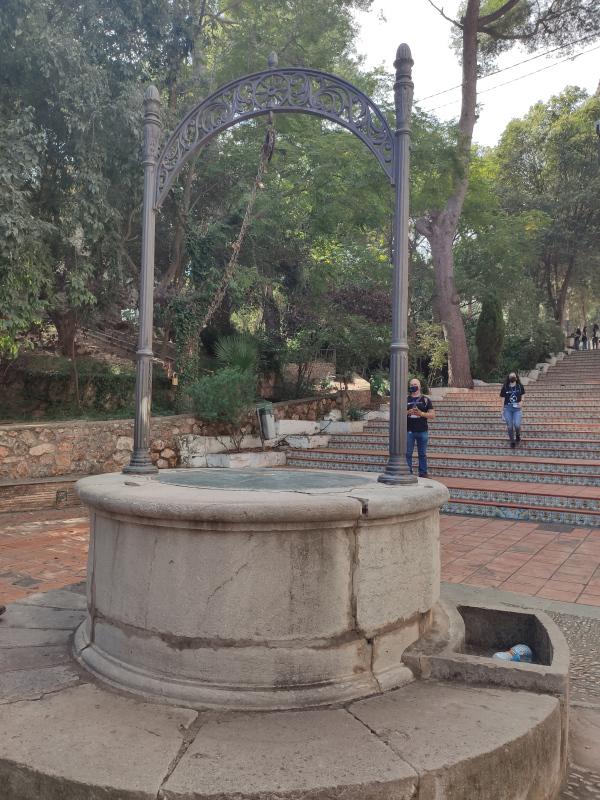 |
| 5 | water source | Fuente del Pastoret d'Ortells. | <p style= ... <p style="text-align: justify; margin: 0px 0px 1em; font-family: Verdana, Arial, Helvetica, sans-serif; font-size: 13.3333px; background-color: rgb(255, 255, 255);">La obra escultórica del Pastoret es la figura emblemática que preside la fuente existente en la plaza del ermitorio y que la gente de Vila-real conoce como la fuente del Pastoret. Obra del escultor José Ortells, Hijo Predilecto de la ciudad, representa la figura del pastorcillo que, según cuenta la leyenda, encontró la imagen de la Virgen de Gracia, dos veces consecutivas y de manera milagrosa, en una de las cuevas naturales de la cantera del Mijares. El hallazgo llevó a los vila-realenses a construir en el lugar un santuario donde, desde entonces, rinden devoción a su patrona.</p><p style="text-align: justify; margin: 0px 0px 1em; font-family: Verdana, Arial, Helvetica, sans-serif; font-size: 13.3333px; background-color: rgb(255, 255, 255);"><img src="https://www.vila-real.es/portal/RecursosWeb/IMAGENES/1/5_39290_1.jpg" alt="El 'Pastoret' d'Ortells"><br></p><p style="text-align: justify; margin: 0px 0px 1em; font-family: Verdana, Arial, Helvetica, sans-serif; font-size: 13.3333px; background-color: rgb(255, 255, 255);">Ortells era un amante del paraje del Termet y cuando se fue de su pueblo para seguir con sus estudios de arte, volvía a Vila-real para pasar los veranos en los alojamientos que había en el ermitorio. El año 1920, impulsado por amigos y residentes en ese entorno en tertulias veraniegas, decide esculpir una sencilla figura con el material que más podía tener al alcance, el cemento, y así y con el fin de embellecer la fuente que el Ayuntamiento estaba construyendo, pide permiso al consistorio para poder poner allí la imagen, ofrecimiento que es aceptado con gran complacencia.</p><p style="text-align: justify; margin: 0px 0px 1em; font-family: Verdana, Arial, Helvetica, sans-serif; font-size: 13.3333px; background-color: rgb(255, 255, 255);">El Pastoret es la primera obra de Ortells que sus vecinas y vecinos conocen y que él, con generosidad, da al pueblo, a su pueblo, a Vila-real. Años después vendrían los reconocimientos populares e institucionales por los éxitos logrados por el artista a nivel nacional.</p><p style="text-align: justify; margin: 0px 0px 1em; font-family: Verdana, Arial, Helvetica, sans-serif; font-size: 13.3333px; background-color: rgb(255, 255, 255);">Cada verano, el Pastoret esperaba el regreso de su creador. Ortells era feliz veraneando en la ermita y siempre procuraba tener habitaciones disponibles para él y su familia. El río, la cantera, el camino de la ermita eran los espacios predilectos para el artista y su Pastoret vigilaba a su creador mientras éste gozaba de la fresca, del silencio y el rumor del agua del río Mijares. El Pastoret ha cumplido 100 años. Testigo mudo de muchos eventos, sigue en pie, con posición relajada mirando la ermita y anhelando la mano de su creador al que Vila-real le rinde tributo como el gran escultor que fue y un vila-realense que siempre llevó a su pueblo en el corazón.</p> |  |
| 6 | water well | Font de Partegat | <p> ... <p><font color="#111111" face="Lato, sans-serif"><span style="font-size: 17px; background-color: rgb(241, 241, 241);">The Font de Partegat Recreational Area, in Benifato, Alicante, is a perfect place to enjoy a family picnic. In addition, from there you can do one of the many hiking trails that start from this wonderful place. It'</span></font>s located on the northern slope of the Sierra de Aitana. This fountain usually has an abundant flow. Its crystal clear waters come from the melting of the highest peaks of the mountain range.</p><p>The Font de Partegat recreational area is signposted at the entrance to the town of Benifato. That is why getting to this natural area is very simple. Access is via a paved forest track. It is a path of about four kilometers that reaches the interior of the Sierra de Aitana. There you will find a car park where you can leave your car. This recreational area has tables and stone seats located under the shade of the poplars. In the place you will also find several barbecues where you can prepare delicious country meals.</p><p>The very source of La Font de Partegat rises a little above the recreation area. The water forms a stream that runs between the tables. Sometimes, in the rainy season, this stream overflows and the area is somewhat flooded. Because of this, it is important that you take into account the time of year that you want to go. Depending on the weather, you should go with waterproof boots and spare shoes.<br></p><p>In addition, in the lower area of the recreational area, the stream flows through a small ditch that can be easily accessed. Therefore, if you go on hot days, there you can cool off with pure and fresh water. That is why the Font de Partegat is a beautiful place to spend a day in the countryside and enjoy nature with the family.<br></p><p><strong>Gateway to the Sierra</strong><br></p><p><font color="#111111" face="Lato, sans-serif"><span style="font-size: 17px; background-color: rgb(241, 241, 241);">One of the great attractions of the Font de Partegat is that it can be considered a gateway to the Sierra de Aitana. Some of the most important trails in the area start from that place. For example, you can take the PRV-21 trail, which connects Benifato with the Port of Tudons. Or the PRV-44 trail, which goes from Callosa to Confrides passing through Benifato.</span></font></p><p><font color="#111111" face="Lato, sans-serif"><span style="font-size: 17px; background-color: rgb(241, 241, 241);">Source: </span><span style="font-size: 17px;">https://saposyprincesas.elmundo.es/actividades-ninos/alicante/aire-libre/rutas-y-excursiones/la-font-de-partegat/</span></font></p> | 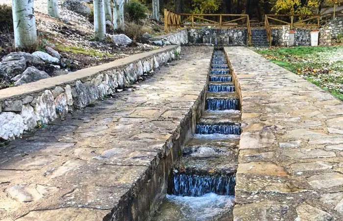 |
| 7 | reservoir | Embalse de Beniarrés | ... <p>The Beniarrés reservoir is located in the municipality of Planes, in the province of Alicante (Spain). It was built in 1958 in the bed of the Serpis river, it occupies an area of 268 hectares, with a maximum capacity of 30 hm³. It has a 53 m high gravity dam, with a gate spillway with a capacity of 1000 m³/s. Fishing is allowed. Carp and black bass are fished, navigation is also allowed. This reservoir belongs to the Júcar Hydrographic Confederation and its waters are used to irrigate the La Safor orchard.<br></p> | 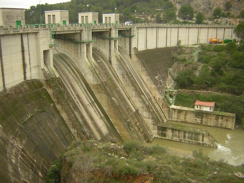 |
| 8 | recreation area | Molí de L'Ombria | <p>Muy ... <p>Muy cerca de su nacimiento en la Font de la Coveta, el Río Vinalopó atraviesa un paraje natural de gran belleza, a los pies de la Serra de la Fontanella, junto a la población de Banyeres de Mariola.</p><p>A orillas del río, los magníficos ejemplares de chopos, sauces y álamos llegan a formar una bóveda natural, una auténtica catedral arbórea que aporta su fresca sombra en los meses de verano, creando un microclima en el lugar donde encontramos el área recreativa y zona de acampada del Molí l’Ombria.</p><p>Un paraje natural idílico, perfecto para desconectar con familia y amigos; los más pequeños de la casa lo disfrutarán al máximo.</p> | 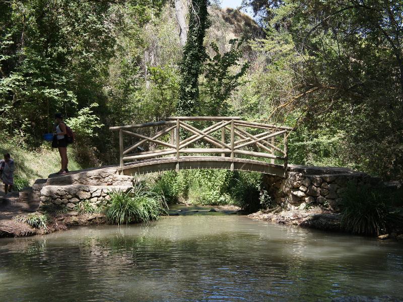 |
| 9 | water source | Fuente de agua potable | <p>Fuente ... <p>Fuente ubicada en la zona ajardinada del Jardí dels Sentits, y que consta de un sencillo grifo con pulsador para poder saciar la sed con agua potable. Como hay árboles alrededor que dan sombra el agua suele estar fresca.</p><p>El Jardí dels Sentits és una zona d’acollida que dona entrada al recinte universitari i es va pensar com un passeig per les diferents formes de percebre el món vegetal a través dels nostres cinc sentits. En la zona de l’olfacte hi ha plantes aromàtiques. En la del gust, arbres fruiters. Per al tacte s’han buscat plantes de troncs més rugosos sobre diferents textures de sòl de bosc. L’oïda és la protagonista a través del so de l’aigua que cau de l’Arbre del Coneixement. I, finalment, en la zona de la vista hi ha una font que corona l’espai i plantes coníferes de grans dimensions.<br></p><p><br></p><p><br></p> |  |
| 10 | water well | Reservorio Biblioteca | Balsa decorativa al ...Balsa decorativa al lado de la Biblioteca y el Rectorado |  |
| 11 | water well | Pozos Garrigós | <p>Th ... <p>The <a href="https://www.aguasdealicante.es/el-museo-de-aguas-de-alicante">Museo de Aguas de Alicante</a> is located in one of the most typical places of the old quarter of Alicante, the Plaza del Puente, next to one of the entrances to the Ereta Park, on the slope of Mount Benacantil, on the top of which stands the Castle of Santa Barbara. </p><p><img src="https://alicanteout.com/wp-content/uploads/museo-aguas-alicante.jpg" alt="Museo de Aguas de Alicante y Pozos de Garrigós - AlicanteOut.com"><br></p><p>The museum has 3 floors. It is a cultural and educational space, available to visitors where they can learn about the history of water in the city. </p><p> Next to the museum are the Garrigós Wells. Although there are doubts about the origin of these wells, it is believed that at least one of them dates from the time of Muslim domination, although the rest are from the sixteenth century. However, in their current configuration they were built in the 19th century to alleviate the effects of the prolonged droughts suffered by the city. They ceased to be used in 1898, when water began to be brought from the nearby town of Sax. The capacities of these dwellings, excavated in the rock, are 141,000, 275,000 and 425,000 dm3. </p> |  |
| 12 | hydroelectric power station | Presa del embalse de Beniarrés | <p st ... <p style="margin: 0.5em 0px; color: rgb(32, 33, 34); font-family: sans-serif; font-size: 14px; background-color: rgb(255, 255, 255);">El <strong>embalse de Beniarrés</strong> se encuentra situado en el municipio de Planes, en la <a href="https://es.wikipedia.org/wiki/Provincia_de_Alicante" title="Provincia de Alicante" style="text-decoration-line: none; color: rgb(6, 69, 173); background-image: none; background-position: initial; background-size: initial; background-repeat: initial; background-attachment: initial; background-origin: initial; background-clip: initial;">provincia de Alicante</a> (<a href="https://es.wikipedia.org/wiki/Espa%C3%B1a" title="España" style="text-decoration-line: none; color: rgb(6, 69, 173); background-image: none; background-position: initial; background-size: initial; background-repeat: initial; background-attachment: initial; background-origin: initial; background-clip: initial;">España</a>).</p><p style="margin: 0.5em 0px; color: rgb(32, 33, 34); font-family: sans-serif; font-size: 14px; background-color: rgb(255, 255, 255);">Se construyó en el año <a href="https://es.wikipedia.org/wiki/1958" title="1958" style="text-decoration-line: none; color: rgb(6, 69, 173); background-image: none; background-position: initial; background-size: initial; background-repeat: initial; background-attachment: initial; background-origin: initial; background-clip: initial;">1958</a> en el cauce del río <a href="https://es.wikipedia.org/wiki/Serpis" title="Serpis" style="text-decoration-line: none; color: rgb(6, 69, 173); background-image: none; background-position: initial; background-size: initial; background-repeat: initial; background-attachment: initial; background-origin: initial; background-clip: initial;">Serpis</a>, ocupa una superficie de 268 hectáreas, con una capacidad máxima de 30 hm³. Tiene una presa de gravedad de 53 m de altura, con aliviadero de compuertas de 1000 m³/s de capacidad. La pesca está permitida. Se pesca carpa y black bass, también se permite la navegación. Este pantano pertenece a la <a href="https://es.wikipedia.org/wiki/Confederaci%C3%B3n_Hidrogr%C3%A1fica_del_J%C3%BAcar" title="Confederación Hidrográfica del Júcar" style="text-decoration-line: none; color: rgb(6, 69, 173); background-image: none; background-position: initial; background-size: initial; background-repeat: initial; background-attachment: initial; background-origin: initial; background-clip: initial;">Confederación Hidrográfica del Júcar</a> y sus aguas se destinan al riego de la huerta de <a href="https://es.wikipedia.org/wiki/La_Safor" class="mw-redirect" title="La Safor" style="text-decoration-line: none; color: rgb(6, 69, 173); background-image: none; background-position: initial; background-size: initial; background-repeat: initial; background-attachment: initial; background-origin: initial; background-clip: initial;">la Safor</a>.</p> | 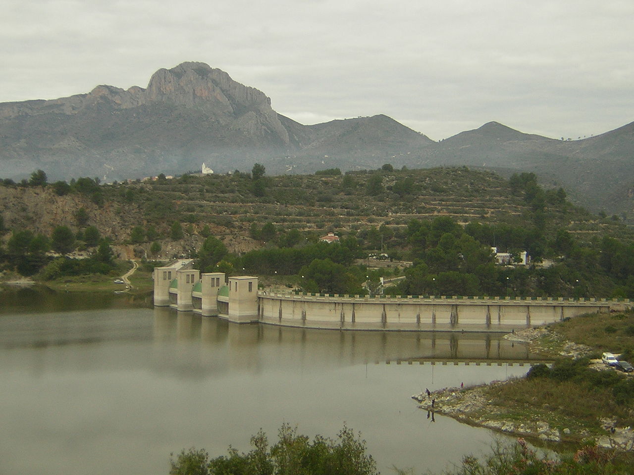 |
| 13 | recreation area | Jardí dels sentits | <p><strong& ...<p><strong>Texto procedente de CastellonTurismo.com:</strong></p><p>El recorrido del Jardín de los sentidos se propone, a partir de una zona de acogida, que da a la entrada al recinto universitario, como un paseo por las distintas maneras de percibir el mundo vegetal a través de nuestros sentidos con la intención de agudizarlos.</p><p><img src="https://www.castellonturismo.com/wp-content/uploads/2010/10/jardin_sentidos021.jpg"><br></p><p>Esta composición vegetal se integra en una idea expositiva general que vertebra todo el recinto universitario y como eje central, comunica las diferentes edificaciones del campus intentando dar sentido a todo el conjunto. El recorrido se puede hacer a través de distintas alternativas de caminos que van encontrándose, en un sentido y en otro, y dan lugar a un sistema ambiguo y fragmentario del espacio, de manera que se huye del recorrido único y monótono, y permite tanto la reunión y relación entre los estudiantes del campus, como que cada persona pueda buscar su propia ruta de paseo o escoger un lugar diferente según su preferencia o estado de ánimo.</p><p style="padding: 0px; margin: 0px 0px 20px; border: 0px; outline: 0px; vertical-align: baseline; background-color: rgb(255, 255, 255); text-align: justify;"><img src="https://www.castellonturismo.com/wp-content/uploads/2010/10/jardin_sentidos031.jpg"><br></p><p style="padding: 0px; margin: 0px 0px 20px; border: 0px; outline: 0px; vertical-align: baseline; background-color: rgb(255, 255, 255); text-align: justify;">Entre sus parajes, el visitante puede encontrar “El café de los sentidos”, cafeterías que se encuentran a lo largo del recorrido del jardín de los sentidos, y donde además de disfrutar del paisaje tomando algo y charlando tranquilamente con los amigos, puede deleitar a sus oídos con los distintos conciertos que se llevan a cabo en ellas.</p><p style="padding: 0px; margin: 0px 0px 20px; border: 0px; outline: 0px; vertical-align: baseline; background-color: rgb(255, 255, 255); text-align: justify;"><img src="https://www.castellonturismo.com/wp-content/uploads/2010/10/jardin_sentidos011.jpg"><br></p> | 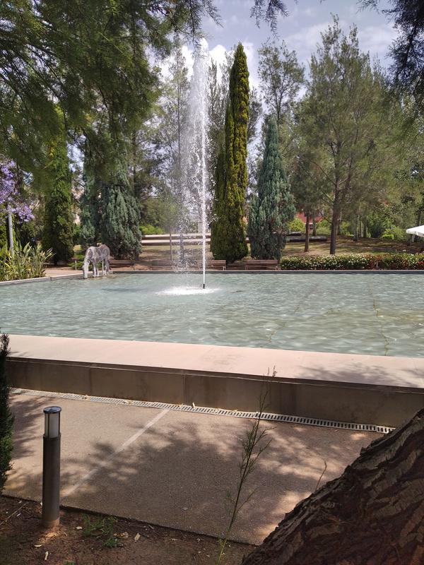 |
| 14 | bridge | Pont del Termet | <p class=&quo ... <p class="MsoNormal" style="color: rgb(153, 153, 153); font-family: Arial, Tahoma, Helvetica, FreeSans, sans-serif; font-size: 13.2px; background-color: rgb(255, 255, 255); text-align: justify;"><span style="line-height: 15.18px;"><span style="color: rgb(68, 68, 68); font-family: arial, helvetica, sans-serif;">Hoy, con gran placer, incorporo a esta colección de puentes una nueva provincia que hasta la fecha, tenía olvidada y carecía de testigos. La obra civil de Castellón que presento está ubicada sobre el río Mijares (Riu Millars) en la ciudad de Villarreal de los Infantes (así la conocí hace muchos años) ahora titulada Vila-real. Este tramo del río circula por la comarca de la Plana Baixa y se muestra profundo, entre altos taludes de arenisca que horada este cauce desde hace millones de años. Está atravesada por la CV-1889, derivación de la N-340<o:p></o:p></span></span></p><p class="MsoNormal" style="color: rgb(153, 153, 153); font-family: Arial, Tahoma, Helvetica, FreeSans, sans-serif; font-size: 13.2px; background-color: rgb(255, 255, 255); text-align: justify;"><span style="line-height: 15.18px;"><img src="https://1.bp.blogspot.com/-OcRBrfvhAJY/W_wjWZQDPfI/AAAAAAAANX8/snuqrrXiIsIpfx4MEx9QTigX-W5M0kMLQCLcBGAs/s320/1%2BHacia%2B1920%2BArchivo%2Bmunicipal%2BVila-real.jpg"><span style="color: rgb(68, 68, 68); font-family: arial, helvetica, sans-serif;"><br></span></span></p><p class="MsoNormal" style="color: rgb(153, 153, 153); font-family: Arial, Tahoma, Helvetica, FreeSans, sans-serif; font-size: 13.2px; background-color: rgb(255, 255, 255); text-align: justify;"><span style="line-height: 15.18px;"><span style="color: rgb(68, 68, 68); font-family: arial, helvetica, sans-serif;">Vila-real es una ciudad próspera en la que predomina su famosa industria de cerámica y <em>greis</em> aunque no descuida la tradición agrícola, especialmente la naranjera. Es la segunda población por número de habitantes de la provincia de Castellón y dispone de varios puentes que salvan el cauce del Mijares. He prestado atención al puente de origen medieval conocido como Pont de Santa Quitèria y al Pont Nou de origen clasicista, ambos ubicados en la vía de comunicación más antigua de la zona, conocida como Vía Augusta, actualmente nacional N-340. Respecto al puente de Termet, decir que su ubicación y orientación me ofrecen dudas pues parece claro que no obedece a necesarias comunicaciones o conexiones N/S, más bien, parece que trata de unir o acceder desde el SE marítimo de Burriana hacia la zona del Maestrazgo o NW, buscando núcleos antiguos como pueden ser Alcora o Lucena del Cid. La calzada local a la que da servicio es la CV-1880 que permite el acceso a la ciudad y a las vías autonómicas CV-20 y CV-10. Aunque en su entorno predominan ahora urbanizaciones como la del Cardenal Tarancón, se aprecian grandes extensiones de viejas masías y huertos de naranjos. Al mismo tiempo y dado que se trata de un paraje bello y natural, al amparo del cercano ermitorio de la Mare de Dèu de Gràcia, se ha conformado una gran área de esparcimiento, con bosquetes de pinos, arbolado de ribera, parques, amplios aparcamientos y diferentes rutas pedestres que -aunque en ningún folleto o panfleto turístico se refleja- dan preponderancia y protagonismo soberano a esta discreta obra civil. En ocasiones, entendemos el turismo rural o natural como una zona o lugar donde se exhibe la geografía en su todo su esplendor, sin otros aditamentos, pero a veces, la huella humana ingenieril se cuela en la panorámica y acentúa visiblemente el lugar o paraje por el que andamos o visitamos. Independientemente de la cualidad de matiz religioso que tiene esta zona así como del cañón que forma el Mijares, el poderío y la espectacularidad de este puente, a mi juicio, incrementa la belleza del paraje.<o:p></o:p></span></span></p><p><span style="line-height: 15.18px;"><span style="color: rgb(68, 68, 68); font-family: arial, helvetica, sans-serif;"><br></span></span></p> |  |
| 15 | swamp | Piscina municipal el Termet | <p>Piscina ol& ...<p>Piscina olímpica</p>
<ul><li><strong>Precio:</strong></li></ul><p style="text-align: justify; margin: 0px 0px 1em;">De 3 a 13 años: 1 €</p><p style="text-align: justify; margin: 0px 0px 1em;">Mayores de 13 años: 2€</p><ul><li><strong>Abonos:</strong></li></ul><p style="text-align: justify; margin: 0px 0px 1em;">10 usos menores de 13 años: 7 €</p><p style="text-align: justify; margin: 0px 0px 1em;">10 usos mayores de 13 años: 15 €</p><h3 class="clear" style="font-family: Verdana, Georgia, sans-serif; font-weight: lighter; color: rgb(77, 78, 83); font-size: 1.1em; margin-top: 0px; margin-bottom: 0.4em; padding-top: 1em; clear: both;">Dirección y datos de contacto</h3><p class="mod_caja" style="margin: -10px 0px 20px; padding: 0px 6px 1px; background: none;"><h4 style="font-family: Verdana, Georgia, sans-serif; font-weight: bold; color: rgb(77, 78, 83); font-size: 1em; margin-top: 20px; margin-bottom: 0px; padding: 5px; border-bottom: 1px solid rgb(220, 218, 204);">Dirección</h4><p style="text-align: justify; margin: 0px; padding: 10px; font-size: 1em;">Ermitori de la Mare de Déu de Gràcia, s/n<br>12540 Vila-real (Castelló)</p><p style="text-align: justify; margin: 0px; padding: 10px; font-size: 1em;"><a href="tel:964547195" style="text-decoration-line: none; color: rgb(227, 85, 19);">Telf: 964 547 195</a><br>Fax: 964 547 191</p></p><p class="mod_caja" style="margin: -10px 0px 20px; padding: 0px 6px 1px; background: none;"><h4 style="font-family: Verdana, Georgia, sans-serif; font-weight: bold; color: rgb(77, 78, 83); font-size: 1em; margin-top: 20px; margin-bottom: 0px; padding: 5px; border-bottom: 1px solid rgb(220, 218, 204);">Horario</h4><ul style="margin: 0.5em 0.1em; padding: 0px; font-size: 1em;"><li style="margin: 0px 0px 0.3em 0.5em; padding: 0px 0px 0px 0.7em; font-size: 1em; list-style: none; background: url("../../img/1/it_mod.gif") 0px 0px no-repeat;"><strong>Periodo de apertura:</strong></li></ul><p style="text-align: justify; margin: 0px; padding: 10px; font-size: 1em;">Del 22 de junio al 31 de agosto de 2018</p><ul style="margin: 0.5em 0.1em; padding: 0px; font-size: 1em;"><li style="margin: 0px 0px 0.3em 0.5em; padding: 0px 0px 0px 0.7em; font-size: 1em; list-style: none; background: url("../../img/1/it_mod.gif") 0px 0px no-repeat;"><strong>Horario:</strong></li></ul><p style="text-align: justify; margin: 0px; padding: 10px; font-size: 1em;">Todos los días de 10:00 a 21:00 horas.</p><br></p><p class="mod_caja2" style="margin: -10px 0px 20px; padding: 0px 6px 1px; background: none;"><h4 style="font-family: Verdana, Georgia, sans-serif; font-weight: bold; color: rgb(77, 78, 83); font-size: 1em; margin-top: 20px; margin-bottom: 0px; padding: 5px; border-bottom: 1px solid rgb(220, 218, 204);">Datos de contacto</h4><p style="text-align: justify; margin: 0px; padding: 10px; font-size: 1em;">Correo electrónico: <a href="mailto:info@esportsvila-real.org" style="text-decoration-line: none; color: rgb(227, 85, 19);">info@esportsvila-real.org</a></p></p> |  |
| 16 | watermill | Moli fariner de l’Ermita o Pedro Benedito | < ... <p>Molino harinero movido por la desviación de aguas del río Mijares, ubicado en su orilla. Recientemente ha sido restaurado y es un ejemplo clásico del aprovechamiento de la fuerza hidráulica.</p><p><span style="color: rgb(51, 51, 51); font-family: Roboto, -apple-system, BlinkMacSystemFont, "Helvetica Neue", Arial, sans-serif; font-size: 18px; background-color: rgb(255, 255, 255);">Runes de l'antic molí Bisbal (pel cognom del primer propietari) o de Tatxes (per una de les últimes ocupacions). Fins ací arriba des de Vila-real el camí del Molí Bisbal, i també hi ha el medidor i regulador nou de l'aigua de la sèquia.</span><br></p><p>Texto obtenido de: www.elperiodicomediterraneo.com</p><p>La Concejalía de Termet, Ermita y Cementerio del Ayuntamiento de Vila-real ha recuperado una antigua tolva y tambor que cubre la piedra volandera del Molino de la Ermita. El trabajo, a cargo de dos empresas locales, ha permitido incorporar las piezas a las actividades didácticas que se desarrollan en el entorno.</p><p><em>"Gracias a esta actuación, contamos de nuevo con estos dos elementos, que nos permiten explicar de forma visual cómo era el proceso de la molienda, uno de los usos que ha tenido este molino"</em>, explica la concejala del área, Rosario Royo. El Molino de la Ermita forma parte de las visitas guiadas que se ofrecen a los centros docentes y otros colectivos, con la colaboración del Consorcio del Mijares y del A.C. El Bressol. Para solicitar la visita sólo hay que remitir la solicitud a la Concejalía del Termet.</p> | 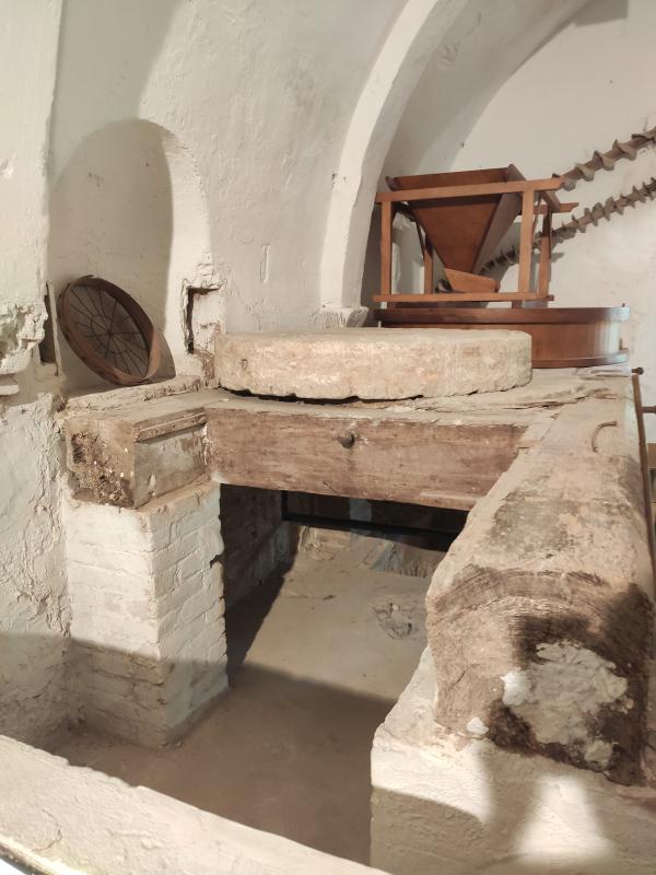 |
| 17 | swamp | Parque inundable la marjal | <p> & ... <p> <a href="https://www.alicante.es/es/equipamientos/parque-marjal">La Marjal</a> Flood Park is located a short distance from <a href="https://es.wikipedia.org/wiki/Playa_de_San_Juan_(Alicante)">Playa de San Juan</a>, in an urban area developed on land that formed a marsh in times past. It is a unique park that, in addition to the leisure and recreation function of any park, fulfills another hydraulic function: in case of heavy rains it is used as a rainwater retention basin, reducing the risk of flooding in the lower part of the neighborhood. being able to store up to 45,000 m3 of water. </p><p><img src="https://www.alicante.es/sites/default/files/styles/img_imagen_nodo/public/imagenes/equipamientos/parque-marjal/1-mirador-marjal.jpg" alt="marjal panorámica"><br></p><h3 style="font-family: " open="" sans",="" helvetica,="" arial,="" sans-serif;="" margin-top:="" 0px;="" margin-bottom:="" 0.8em;="" padding:="" border:="" outline:="" vertical-align:="" baseline;="" font-variant-numeric:="" inherit;="" font-variant-east-asian:="" font-stretch:="" font-size:="" 1.25em;="" line-height:="" 1.477;="" font-weight:="" 600;="" letter-spacing:="" -0.05em;="" color:="" rgb(51,="" 51,="" 51);="" text-align:="" justify;="" background-color:="" rgb(255,="" 255,="" 255);"="">DESCRIPCIÓN GENERAL:</h3><p style="font-family: " open="" sans",="" helvetica,="" arial,="" sans-serif;="" margin:="" 0px="" 1em;="" padding:="" 0px;="" border:="" outline:="" vertical-align:="" baseline;="" font-variant-numeric:="" inherit;="" font-variant-east-asian:="" font-stretch:="" font-size:="" 14px;="" line-height:="" text-align:="" justify;="" color:="" rgb(45,="" 45,="" 46);="" background-color:="" rgb(255,="" 255,="" 255);"="">El Parque de inundación La Marjal está situado a escasa distancia de la Playa de San Juan, en una zona urbana desarrollada sobre los terrenos que formaban una marjal en tiempos pasados. Es un parque singular que, además de la función de ocio y esparcimiento de todo parque, cumple otra función hidráulica: en caso de lluvias fuertes se sirve como vaso de retención de aguas pluviales, reduciendo el riesgo de inundación en la parte baja del barrio, pudiendo almacenar hasta 45.000 m3 de agua.</p><p style="font-family: " open="" sans",="" helvetica,="" arial,="" sans-serif;="" margin:="" 0px="" 1em;="" padding:="" 0px;="" border:="" outline:="" vertical-align:="" baseline;="" font-variant-numeric:="" inherit;="" font-variant-east-asian:="" font-stretch:="" font-size:="" 14px;="" line-height:="" text-align:="" justify;="" color:="" rgb(45,="" 45,="" 46);="" background-color:="" rgb(255,="" 255,="" 255);"="">En el interior del vaso de retención hay un gran estanque rodeado de vegetación acuática donde puede observarse la flora y fauna propia de los humedales naturales valencianos (marjales). Para el mantenimiento del agua en condiciones adecuadas se dispone de un circuito de recirculación que incluye una cascada, un estanque pequeño y un rápido.</p><p style="font-family: " open="" sans",="" helvetica,="" arial,="" sans-serif;="" margin:="" 0px="" 1em;="" padding:="" 0px;="" border:="" outline:="" vertical-align:="" baseline;="" font-variant-numeric:="" inherit;="" font-variant-east-asian:="" font-stretch:="" font-size:="" 14px;="" line-height:="" text-align:="" justify;="" color:="" rgb(45,="" 45,="" 46);="" background-color:="" rgb(255,="" 255,="" 255);"="">Una colina formada con las tierras procedentes de la excavación del vaso de retención proporciona excelentes vistas sobre el parque y la comarca de l'Alacantí, con las montañas al fondo. Además recrea la vegetación de montaña y el paisaje agrícola mediterráneo.</p><p style="font-family: " open="" sans",="" helvetica,="" arial,="" sans-serif;="" margin:="" 0px="" 1em;="" padding:="" 0px;="" border:="" outline:="" vertical-align:="" baseline;="" font-variant-numeric:="" inherit;="" font-variant-east-asian:="" font-stretch:="" font-size:="" 14px;="" line-height:="" text-align:="" justify;="" color:="" rgb(45,="" 45,="" 46);="" background-color:="" rgb(255,="" 255,="" 255);"="">Este parque ha sido galardonado por la Asociación Española de Parques y Jardines Públicos con el premio Alhambra al mejor proyecto del año 2015.</p><h3 style="font-family: " open="" sans",="" helvetica,="" arial,="" sans-serif;="" margin-top:="" 0px;="" margin-bottom:="" 0.8em;="" padding:="" border:="" outline:="" vertical-align:="" baseline;="" font-variant-numeric:="" inherit;="" font-variant-east-asian:="" font-stretch:="" font-size:="" 1.25em;="" line-height:="" 1.477;="" font-weight:="" 600;="" letter-spacing:="" -0.05em;="" color:="" rgb(51,="" 51,="" 51);="" text-align:="" justify;="" background-color:="" rgb(255,="" 255,="" 255);"="">INSTALACIONES:</h3><ul style="font-family: " open="" sans",="" helvetica,="" arial,="" sans-serif;="" margin:="" 0px="" 1.846em="" 1em;="" padding:="" 1.2em;="" border:="" 0px;="" outline:="" vertical-align:="" baseline;="" font-variant-numeric:="" inherit;="" font-variant-east-asian:="" font-stretch:="" font-size:="" 14px;="" line-height:="" list-style-position:="" outside;="" list-style-image:="" initial;="" overflow:="" hidden;="" color:="" rgb(45,="" 45,="" 46);="" text-align:="" justify;="" background-color:="" rgb(255,="" 255,="" 255);"=""><li style="font: inherit; margin: 0px; padding: 0px 2em 0px 0px; border: 0px; outline: 0px; vertical-align: baseline; list-style: disc; position: relative; left: 2em;">Mirador</li><li style="font: inherit; margin: 0px; padding: 0px 2em 0px 0px; border: 0px; outline: 0px; vertical-align: baseline; list-style: disc; position: relative; left: 2em;">Paneles explicativos</li><li style="font: inherit; margin: 0px; padding: 0px 2em 0px 0px; border: 0px; outline: 0px; vertical-align: baseline; list-style: disc; position: relative; left: 2em;">Aparatos para realizar ejercicios físicos</li><li style="font: inherit; margin: 0px; padding: 0px 2em 0px 0px; border: 0px; outline: 0px; vertical-align: baseline; list-style: disc; position: relative; left: 2em;">Pasarela de comunicación con el Parque urbano</li><li style="font: inherit; margin: 0px; padding: 0px 2em 0px 0px; border: 0px; outline: 0px; vertical-align: baseline; list-style: disc; position: relative; left: 2em;">Nidales para la reproducción de aves</li><li style="font: inherit; margin: 0px; padding: 0px 2em 0px 0px; border: 0px; outline: 0px; vertical-align: baseline; list-style: disc; position: relative; left: 2em;">Aparcamiento de bicicletas</li><li style="font: inherit; margin: 0px; padding: 0px 2em 0px 0px; border: 0px; outline: 0px; vertical-align: baseline; list-style: disc; position: relative; left: 2em;">Instalación de alarma, en caso de inundación</li><li style="font: inherit; margin: 0px; padding: 0px 2em 0px 0px; border: 0px; outline: 0px; vertical-align: baseline; list-style: disc; position: relative; left: 2em;">Panel informativo</li></ul><h3 style="font-family: " open="" sans",="" helvetica,="" arial,="" sans-serif;="" margin-top:="" 0px;="" margin-bottom:="" 0.8em;="" padding:="" border:="" outline:="" vertical-align:="" baseline;="" font-variant-numeric:="" inherit;="" font-variant-east-asian:="" font-stretch:="" font-size:="" 1.25em;="" line-height:="" 1.477;="" font-weight:="" 600;="" letter-spacing:="" -0.05em;="" color:="" rgb(51,="" 51,="" 51);="" text-align:="" justify;="" background-color:="" rgb(255,="" 255,="" 255);"="">ACTIVIDADES:</h3><ul style="font-family: " open="" sans",="" helvetica,="" arial,="" sans-serif;="" margin:="" 0px="" 1.846em="" 1em;="" padding:="" 1.2em;="" border:="" 0px;="" outline:="" vertical-align:="" baseline;="" font-variant-numeric:="" inherit;="" font-variant-east-asian:="" font-stretch:="" font-size:="" 14px;="" line-height:="" list-style-position:="" outside;="" list-style-image:="" initial;="" overflow:="" hidden;="" color:="" rgb(45,="" 45,="" 46);="" text-align:="" justify;="" background-color:="" rgb(255,="" 255,="" 255);"=""><li style="font: inherit; margin: 0px; padding: 0px 2em 0px 0px; border: 0px; outline: 0px; vertical-align: baseline; list-style: disc; position: relative; left: 2em;">Visitas escolares para la educación ambiental</li><li style="font: inherit; margin: 0px; padding: 0px 2em 0px 0px; border: 0px; outline: 0px; vertical-align: baseline; list-style: disc; position: relative; left: 2em;">Observación de aves</li><li style="font: inherit; margin: 0px; padding: 0px 2em 0px 0px; border: 0px; outline: 0px; vertical-align: baseline; list-style: disc; position: relative; left: 2em;">Paseos</li></ul><h3 style="font-family: " open="" sans",="" helvetica,="" arial,="" sans-serif;="" margin-top:="" 0px;="" margin-bottom:="" 0.8em;="" padding:="" border:="" outline:="" vertical-align:="" baseline;="" font-variant-numeric:="" inherit;="" font-variant-east-asian:="" font-stretch:="" font-size:="" 1.25em;="" line-height:="" 1.477;="" font-weight:="" 600;="" letter-spacing:="" -0.05em;="" color:="" rgb(51,="" 51,="" 51);="" text-align:="" justify;="" background-color:="" rgb(255,="" 255,="" 255);"="">UBICACIÓN:</h3><p style="font-family: " open="" sans",="" helvetica,="" arial,="" sans-serif;="" margin:="" 0px="" 1em;="" padding:="" 0px;="" border:="" outline:="" vertical-align:="" baseline;="" font-variant-numeric:="" inherit;="" font-variant-east-asian:="" font-stretch:="" font-size:="" 14px;="" line-height:="" text-align:="" justify;="" color:="" rgb(45,="" 45,="" 46);="" background-color:="" rgb(255,="" 255,="" 255);"="">Acceso principal por rotonda Avenidas de Oviedo – de las Naciones - Locutor Vicente Hipólito – Pintor Pérezgil.</p><h3 style="font-family: " open="" sans",="" helvetica,="" arial,="" sans-serif;="" margin-top:="" 0px;="" margin-bottom:="" 0.8em;="" padding:="" border:="" outline:="" vertical-align:="" baseline;="" font-variant-numeric:="" inherit;="" font-variant-east-asian:="" font-stretch:="" font-size:="" 1.25em;="" line-height:="" 1.477;="" font-weight:="" 600;="" letter-spacing:="" -0.05em;="" color:="" rgb(51,="" 51,="" 51);="" text-align:="" justify;="" background-color:="" rgb(255,="" 255,="" 255);"="">TRANSPORTE PÚBLICO</h3><ul style="font-family: " open="" sans",="" helvetica,="" arial,="" sans-serif;="" margin:="" 0px="" 1.846em="" 1em;="" padding:="" 1.2em;="" border:="" 0px;="" outline:="" vertical-align:="" baseline;="" font-variant-numeric:="" inherit;="" font-variant-east-asian:="" font-stretch:="" font-size:="" 14px;="" line-height:="" list-style-position:="" outside;="" list-style-image:="" initial;="" overflow:="" hidden;="" color:="" rgb(45,="" 45,="" 46);="" text-align:="" justify;="" background-color:="" rgb(255,="" 255,="" 255);"=""><li style="font: inherit; margin: 0px; padding: 0px 2em 0px 0px; border: 0px; outline: 0px; vertical-align: baseline; list-style: disc; position: relative; left: 2em;"><strong style="font-family: inherit; margin: 0px; padding: 0px; border: 0px; outline: 0px; vertical-align: baseline; font-style: inherit; font-variant: inherit; font-weight: bold; font-stretch: inherit; font-size: inherit; line-height: inherit;">Tram</strong>: Parada más cercana: Avenida de Oviedo (frente a los números 8 y 10)</li><li style="font: inherit; margin: 0px; padding: 0px 2em 0px 0px; border: 0px; outline: 0px; vertical-align: baseline; list-style: disc; position: relative; left: 2em;"><strong style="font-family: inherit; margin: 0px; padding: 0px; border: 0px; outline: 0px; vertical-align: baseline; font-style: inherit; font-variant: inherit; font-weight: bold; font-stretch: inherit; font-size: inherit; line-height: inherit;">Bus nº 22</strong>: Parada más cercana: Avenida de Oviedo, 12</li></ul> | 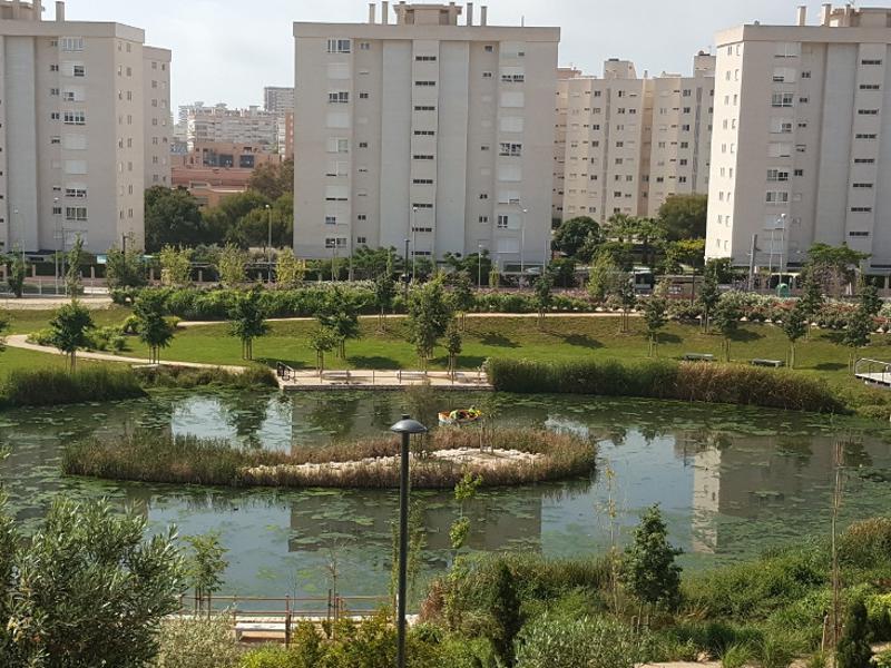 |
| 18 | weir | Azud del molino de Bisbal | <p> ... <p>Pequeño dique de retención de aguas para acumulación de ésta y laminar las crecidas del río Mijares. </p><p>Forma parte del sistema de alimentación de fuerza hidráulica al molíno de Bisbal.</p><p>Formado a partir de piedras de grandes dimensiones y cemento. Está situado en una zona muy tranquila en el área recreativa del Termet</p> |  |
| 19 | water source | Fuente de los criados del Pantano de Tibi | <p>Al suroeste ...<p>Al suroeste de la presa de Tibi, sobre una ladera orientada al Este, se encuentran los restos de algunas casas que, según la <span style="font-weight: bolder;">inscripción </span>de esta <span style="font-weight: bolder;">fuente, </span>datada en el año <span style="font-weight: bolder;">1795</span>, debieron pertenecer a <span style="font-weight: bolder;">«los criados del pantano»</span>. Hay una pequeña senda, junto al camino asfaltado, que podemos tomar para ver brevemente los restos de estas casas, así como la fuente con su inscripción, por orden del Rey Carlos IV.<br></p> |  |
| 187 | bridge | Puente de Santa Quiteira | <p style="ma ...<p style="margin: 0.5em 0px; color: rgb(32, 33, 34); font-family: sans-serif; font-size: 14px; background-color: rgb(255, 255, 255);">El <strong>puente de Santa Quiteria</strong> se sitúa sobre el <a href="https://es.wikipedia.org/wiki/R%C3%ADo_Mijares" title="Río Mijares" style="text-decoration-line: none; color: rgb(6, 69, 173); background-image: none; background-position: initial; background-size: initial; background-repeat: initial; background-attachment: initial; background-origin: initial; background-clip: initial;">río Mijares</a>, entre los términos municipales de <a href="https://es.wikipedia.org/wiki/Almazora" title="Almazora" style="text-decoration-line: none; color: rgb(6, 69, 173); background-image: none; background-position: initial; background-size: initial; background-repeat: initial; background-attachment: initial; background-origin: initial; background-clip: initial;">Almazora</a> y <a href="https://es.wikipedia.org/wiki/Villarreal" title="Villarreal" style="text-decoration-line: none; color: rgb(6, 69, 173); background-image: none; background-position: initial; background-size: initial; background-repeat: initial; background-attachment: initial; background-origin: initial; background-clip: initial;">Villarreal</a> en la <a href="https://es.wikipedia.org/wiki/Provincia_de_Castell%C3%B3n" title="Provincia de Castellón" style="text-decoration-line: none; color: rgb(6, 69, 173); background-image: none; background-position: initial; background-size: initial; background-repeat: initial; background-attachment: initial; background-origin: initial; background-clip: initial;">provincia de Castellón</a>, y fue construido en el <a href="https://es.wikipedia.org/wiki/Siglo_XIII" title="Siglo XIII" style="text-decoration-line: none; color: rgb(6, 69, 173); background-image: none; background-position: initial; background-size: initial; background-repeat: initial; background-attachment: initial; background-origin: initial; background-clip: initial;">siglo XIII</a></p><p style="margin: 0.5em 0px; color: rgb(32, 33, 34); font-family: sans-serif; font-size: 14px; background-color: rgb(255, 255, 255);">Está incluido en el entorno de protección del Paisaje Protegido de la <a href="https://es.wikipedia.org/wiki/Desembocadura_del_Mijares" title="Desembocadura del Mijares" style="text-decoration-line: none; color: rgb(6, 69, 173); background-image: none; background-position: initial; background-size: initial; background-repeat: initial; background-attachment: initial; background-origin: initial; background-clip: initial;">Desembocadura del Río Mijares</a>.</p><p style="margin: 0.5em 0px; color: rgb(32, 33, 34); font-family: sans-serif; font-size: 14px; background-color: rgb(255, 255, 255);"><strong>DESCRIPCIÓN</strong></p><p style="margin: 0.5em 0px; color: rgb(32, 33, 34); font-family: sans-serif; font-size: 14px; background-color: rgb(255, 255, 255);">Con una longitud de 154 metros y una anchura de 3 metros, el puente como tal constituye una pieza única entre las tipologías de puentes medievales al estar construido con arcos en lugar de bóvedas. Está formado por dos estribos extremos, siete pilas intermedias con tajamares, y ocho vanos, siete de ellos semejantes, con luces de 12 metros aproximadamente, y otro más corto de 6,80 metros. Los tajamares aguas arriba se prolongan hasta la altura de los pretiles, formando en la calzada unos espacios laterales de forma triangular llamados arrimaderos, que hacen compatible el paso de vehículos y peatones.</p><p style="margin: 0.5em 0px; color: rgb(32, 33, 34); font-family: sans-serif; font-size: 14px; background-color: rgb(255, 255, 255);">Los tajamares y pilas son de sillería hasta el arranque de los arcos, altura a partir de la cual se utiliza mampostería, excepto en las esquinas donde se continúa con sillares. Los arcos son de una sola rosca de dovelas de piedra arenisca. Sobre esta rosca se elevan las enjutas con una fábrica de mampuestos irregulares hasta alcanzar el nivel del tablero, formado por losas de piedra que se apoyan en forma de dinteles. Los pretiles están construidos también con fábrica de mampuestos.</p> | 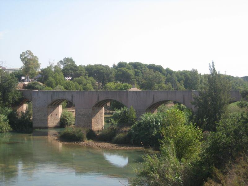 |
| 214 | dam | Conca di porta cairoli | ... | |
| 215 | canal | Conca di Porta Cairoli | <p>It ... <p>It allows to overcome the unevennes of the canal for navigation. The Project has been developed thanks to Napoleone’s engineers, but it was build under austro-hungarian reign.</p> |  |
| 216 | bridge | Ponte sul Naviglio | ... |  |
| 217 | canal | Bi-Conca Botanica | <p>It ... <p>It consitutes the first part of Scala d’Acqua monument. The monument is consituted by 2 double basins (Botanica and Garibaldi) and by the last basin called Conca del Confluente.</p><p>The whole structure was built in 1819.</p> |  |
| 219 | dam | Casetta di comando | <p>This is ... <p>This is a command house in which a technician was able to manage the basin gate to allow the passage of the boats.</p> | 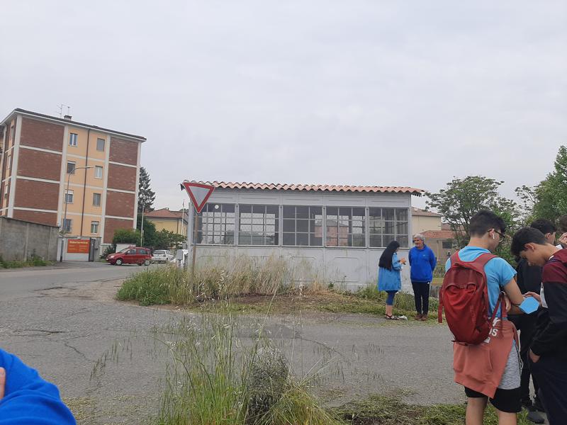 |
| 220 | bridge | Ponte ferroviario | <p>The tra ... <p>The train bridge was built after mid 1800. The arrival of the railway in Pavia due to the fast transportation of the train, and brought slowly to make the naviglio unused.</p> | 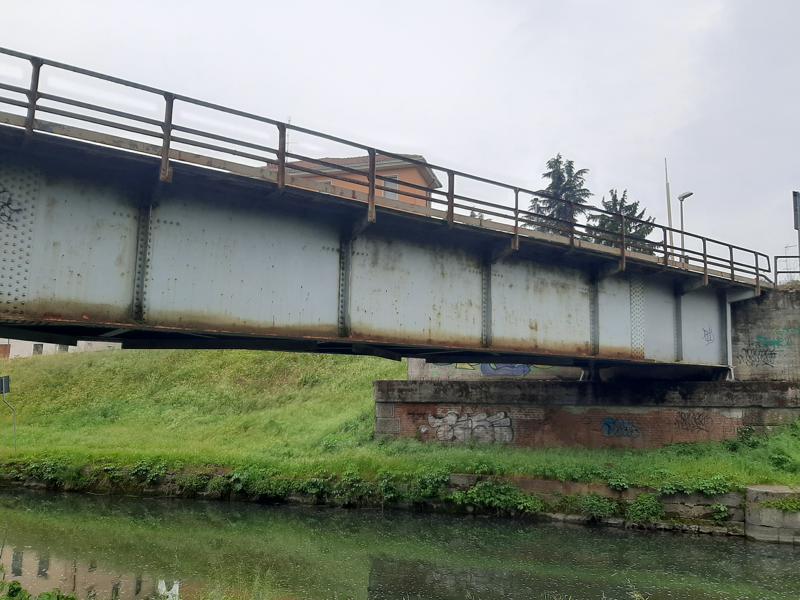 |
| 221 | canal | Bi-Conca Garibaldi | <p>It ... <p>It consitutes the second part of Scala d’Acqua monument.<br></p> |  |
| 222 | dam | Manufatti idraulici | <p>In the ... <p>In the Bi-Conca Garibaldi are visible all the artifacts that permit the gate opening.<br></p> | 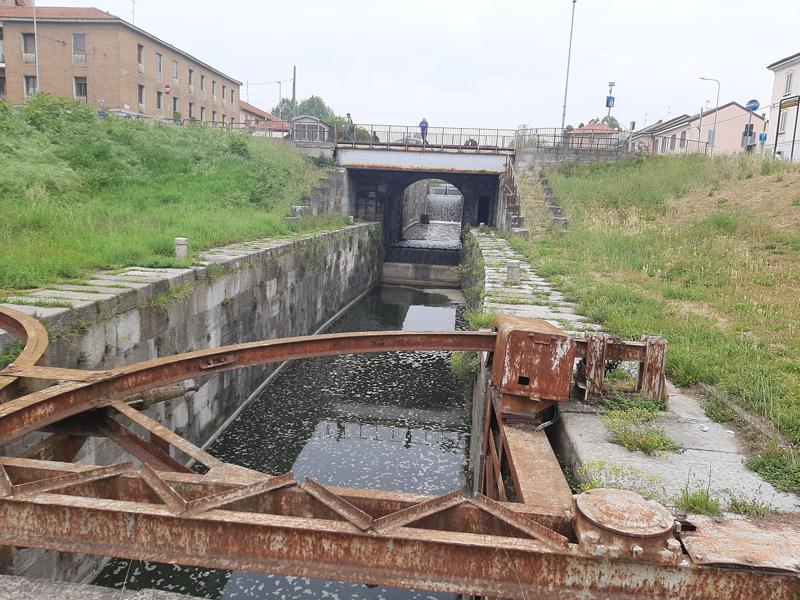 |
| 224 | dam | Bocca in fregio | <p>It has ... <p>It has been constructed in parallel with the Naviglio Pavese during the first years of 1800. It was necessary to divert water in excess.</p> | 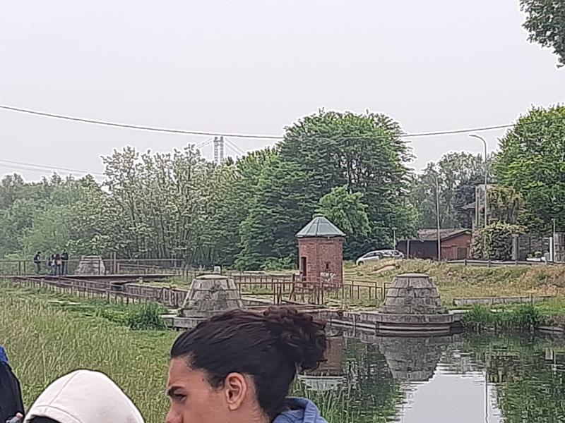 |
| 225 | dam | Torretta esagonale | <p>It ... <p>It is the only hexagonal brick tower that still remains in Pavia.<br></p> |  |
| 226 | recreation area | Borgo Calvenzano | <p>Bor ... <p>Borgo Calvenzano is a complex of buildings designed as a commercial infrastructure of the Naviglio Pavese. It was built in 1816.</p> |  |
| 227 | dam | Hydraulic Lock | <p>It was ... <p>It was necessary to divert water in excess.</p> |  |
| 229 | bridge | Ponte Tasso | ... |  |
| 248 | canal | Conca del confluente | <p>It ... <p>It consitutes the last part of Scala d’Acqua monument. Thisis the last part of the Naviglio in which the canal water flows in the Ticino River.</p> |  |
| 249 | laundry | Llavador Pont la Bassa | <p>Actualm ... <p>Actualmente el lavadero se encuentra junto a un parque infantil que recibe el mismo nombre de parque del lavadero.</p><p>En el pasado Busot fue un lugar afortunado en fuentes de aguas. Gracias al caudal de sus manantiales, se estableció un sistema de riego hacia las huertas desde el Pont la Bassa, donde existía una balsa desde la cual se canalizaba el agua para el uso de los agricultores. Aún perdura el abrevadero con lavadero conocido como “El Llavador”, que a día de hoy se conserva con cariño, testigo de aquella época en la que las mujeres se congregaban para hacer la colada y los animales saciaban su sed.</p><p>Artículo original en: <a href="https://www.lavaderospublicos.net/2019/09/lavadero-pont-la-bassa.html">https://www.lavaderospublicos.net/2019/09/lavadero-pont-la-bassa.html</a></p> | 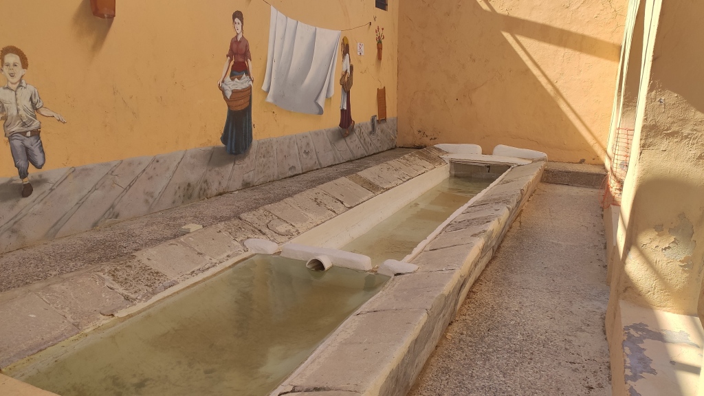 |
| 259 | bridge | Pont de la Pobla del Bellestar | <p>El puente d ...<p>El puente del siglo XIII es una joya patrimonial del medievo valenciano, un precioso puente trecentista y gótico que cruza el río de les Truites. El puente, de arco apuntado, construido en su mayor parte con la técnica de piedra en seco, Patrimonio de la Humanidad, dispone de un solo ojo con unos 60 metros de longitud.<br></p> | 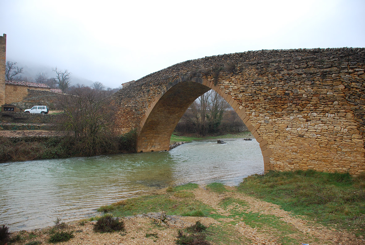 |
| 260 | watermill | Molí del Sol de la Costa | <p>Se trata de ...<p>Se trata de un elemento hidráulico que no consume agua, la aprovecha. Es un molino de rueda horizontal que sirvió desde el siglo XVIII para moler cereales. El molino lo forma una balsa de retención del agua (bassa), una torre o rampa, según cada caso, de caída de agua (cup) y la acequia de canalización de agua que los conecta (séquies) al cauce natural del río.<br></p> |  |
| 301 | water source | Fonte das Negras | <p>In 1936, as ...<p>In 1936, as the legend says in that place, there was the "convent das Negras", hence the name of that source, the legend says that after the convent was destroyed, the owner of the land found some pieces of marble from the old building, with these pieces of marble he sent building the fountain, its beauty is due to the tiles found in it, it is composed of a fountain where the animals will quench their thirst. The source has its origin in the place where today the fire station is installed, this fountain is well preserved. <span class="EOP SCXW168654716 BCX2" style="font-size: 11pt; line-height: 20px; font-family: "inherit", "inherit_EmbeddedFont", "inherit_MSFontService", sans-serif; color: rgb(32, 33, 36);" data-ccp-props="{"201341983":2,"335559739":0,"335559740":540,"469777462":[916,1832,2748,3664,4580,5496,6412,7328,8244,9160,10076,10992,11908,12824,13740,14656],"469777927":[0,0,0,0,0,0,0,0,0,0,0,0,0,0,0,0],"469777928":[1,1,1,1,1,1,1,1,1,1,1,1,1,1,1,1]}"><br></span></p> |  |
| 302 | aqueduct | Aqueduct Sec River | The irrigation chann ...The irrigation channel of Coscollosa draws an almost perfect arc from its source on the edge of the wall until it reaches the ravine of the Magdalena. In its layout it crosses the Seco river by a wide point and with a great unevenness where always there | 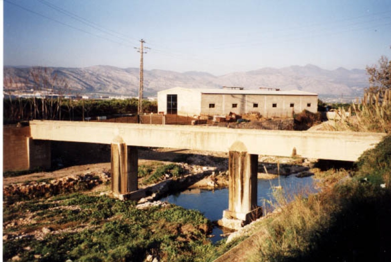 |
| 303 | aqueduct | Barranc del Malvestit Aqueduct | The aqueduct was bui ...The aqueduct was built at the end of the 19th century for the Fomento irrigation channel to cross the Malvestit ravine. The construction presents a very solid invoice of a single arch of average point that has a light of 3,95 m and the intrados makes 2 m |  |
| 304 | aqueduct | Barranc d’Almela Aqueduct | The aqueduct was bui ...The aqueduct was built at the end of the 18th century for the Mercader irrigation channel to cross the Almela ravine. The construction presents a very solid construction of a single semicircular arch. The eye of the arch has a span of 5.75 m on abutments |  |
| 305 | aqueduct | Barranquet Aqueduct | The main irrigation ...The main irrigation channel of Castelló overcomes the Almassora ravine through a narrow and steeply sloping point by means of the construction of an aqueduct. The work presents a very solid invoice of a single lowered arch, the eye of which is 2 meters |  |
| 306 | weir | Moros Booths | The Caseta de los Mo ...The Caseta de los Moros corresponds to the house and gates of the medieval dam of Castelló/Almassora. It was a single-storey building, with three attached naves, and with barrel vaults resting on the arcades of the three existing water inlets at the bot | 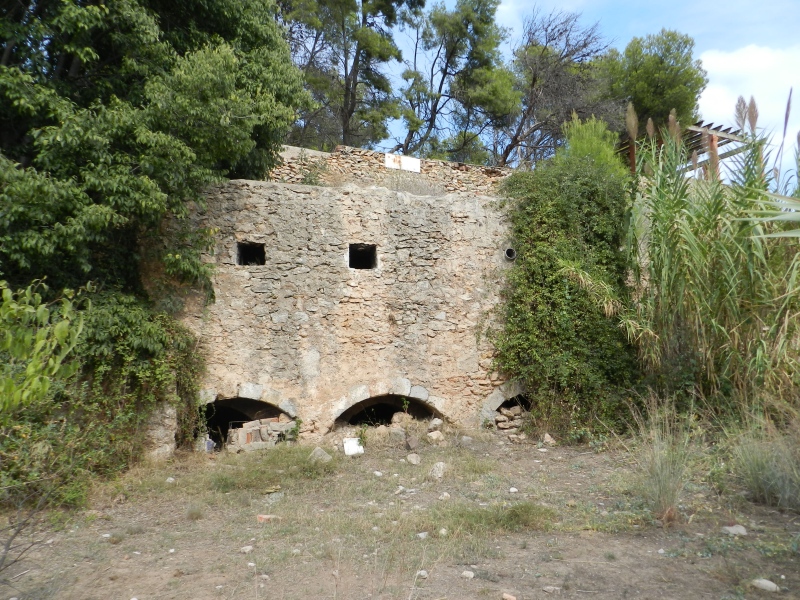 |
| 307 | weir | Castelló/Almassora Weir | The current Castell� ...The current Castelló/Almassora weir is a rectilinear construction that is arranged obliquely to the river bed. It is made of ashlars and mortar, and consists of a dam or wall 2.75 meters high and 106 meters long, with a base that exceeds 5 meters, reduc | 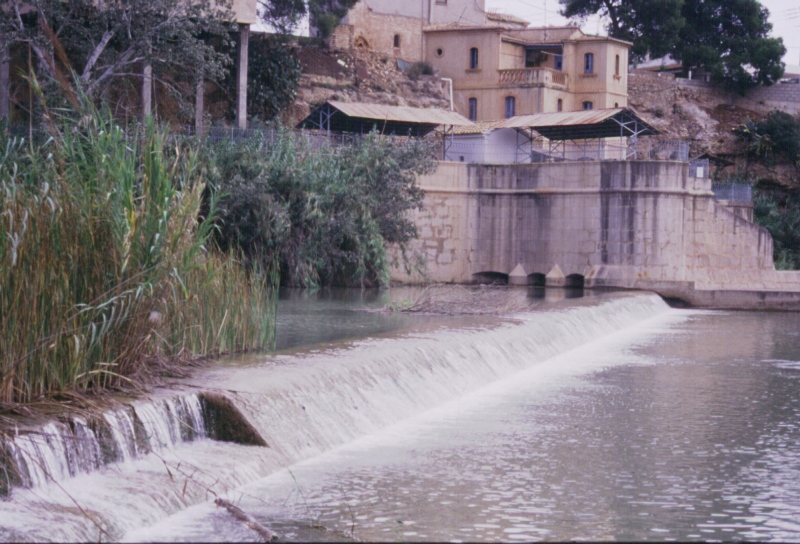 |
| 308 | weir | Reyes House | The Casa de las Reja ...The Casa de las Rejas is a building that contains in its interior the tajamar or partition that separates the water between the major irrigation ditches of Castelló and Almassora. The origin of the gate house dates back to the end of the 18th century, w |  |
| 309 | weir | Castelló/Almassora New Weir | The 1618 weir of Cas ...The 1618 weir of Castelló and Almassora only conserves a small part of its dike, built with large stone slabs and mortar to hold them to the conglomerate of the riverbed. Its layout also points to a rectilinear shape that channeled the water to the same |  |
| 310 | water source | Sec River Channel | One of the main obst ...One of the main obstacles that the Major de Castelló irrigation channel has to overcome in the final stretch is the Seco river. At this point there was a spout or boot, the section of which responds to two short and slight slopes at the ends that were j | 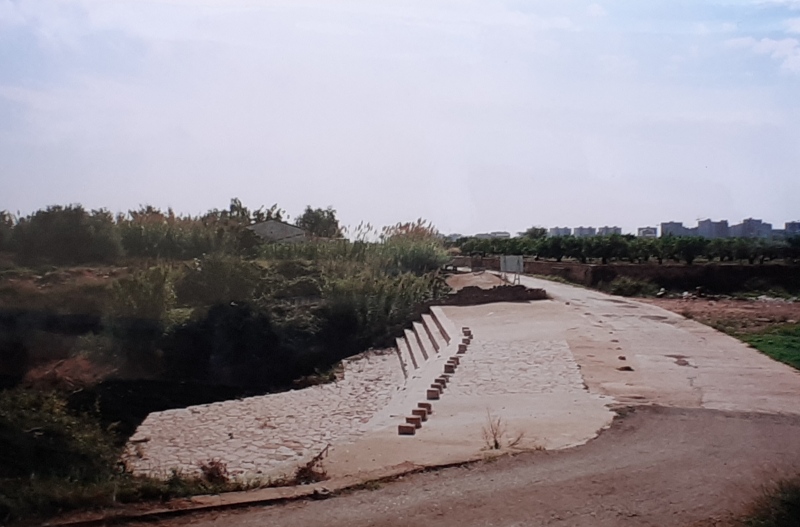 |
| 311 | spring | Font de la Reina | Fuente la Reina is a ...Fuente la Reina is a natural freshwater spring, which gives an irregular flow but always less than 1 m³. Its location corresponds to its point of spoil of the mountain range of the Desert, and line of connection between the dry land and the traditional | 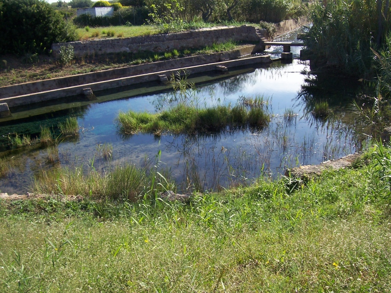 |
| 312 | watermill | Darrer Mill | Mill located downstr ...Mill located downstream of the three built in the fourteenth century in the section between the partidor of Coscollosa and Seco river. The name Masquefa is the surname of its owner in the 16th century. It was built on the outlet of the Major de Castelló | 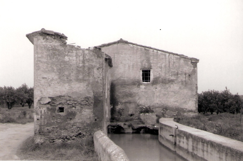 |
| 313 | watermill | Roder Mill | The mill was located ...The mill was located on the main irrigation channel of Castelló, next to the medieval town center, in the southeast end of the walled area, where today is the Borrull square. The oldest reference to the name of Roder mill dates from the second half of t |  |
| 314 | watermill | Soterrani Mill | The mill was built i ...The mill was built in the 14th century on the Sótano row, which rises from the main irrigation channel, at the height of the medieval town of Castelló, and flows towards the sea along the current Curtidurías street. The mill was located at the head of |  |
| 315 | watermill | Olzina Mill | This is one of the m ...This is one of the medieval mills that operated in Castelló throughout the fourteenth and fifteenth centuries, although today there is no trace of its exact location. The name it had corresponds to that of its owner in the 14th century, which was mainta | |
| 316 | watermill | Casalduch Mill | The origin of the mi ...The origin of the mill is medieval, but it has undergone numerous modifications that have altered both the original building and the hydraulic part. The architectural basis of the present building dates back to the end of the 19th century. It is a buildi |  |
| 317 | watermill | Primer Mill | The mill building wa ...The mill building was located in the Taixida district, but is now fully integrated into the urban fabric of the city. It was a simple architectural structure of medieval origin, which consisted of a nave of elongated plant arranged transversely on the ir | 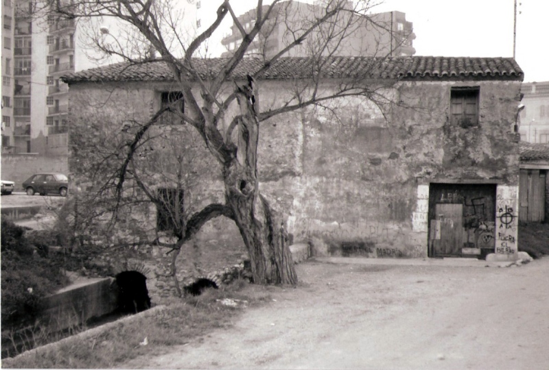 |
| 318 | watermill | Font Mill | The mill was built j ...The mill was built just where the route of the Major irrigation channel ends, in the area of Fuente la Reina. The construction that is still standing today corresponds to a building that has been enlarged and retouched in the last centuries, with outbuil | 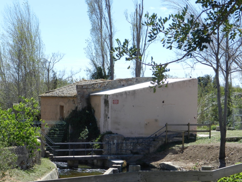 |
| 319 | watermill | Romeral Mill | The name of this mil ...The name of this mill already appears in the 14th century, and in the middle years of the 15th century it was also called the mill of the suburb. It continued to function until the end of the 19th century, when it stopped paying its water rights to the S | 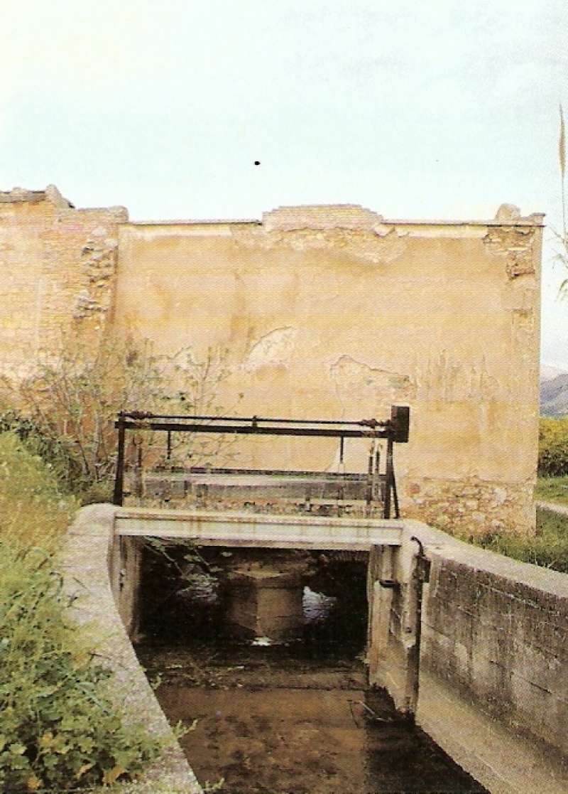 |
| 320 | watermill | Mitjà Mill | The mill was located ...The mill was located in the Ramo district, but urban growth has completely incorporated it into the urban fabric. The mill is the only one of the three that existed in the stretch of the irrigation ditch to the river Seco, which has remained standing to |  |
| 321 | watermill | Mercader Mill | The group of buildin ...The group of buildings that made up the Mercader mill was located in the Benadressa district, above the route of the new Mercader irrigation channel that was built at the end of the 18th century on the left bank of the Rambla de la Viuda, and next to the | 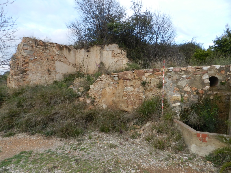 |
| 322 | watermill | Gombau Mill | The name of the mill ...The name of the mill corresponds to the surname of the family of its first owners and builders in the 16th century. It was located in the orchard of Castelló, in the Gombau district, on the homonymous row that starts perpendicularly from the main irriga |  |
| 323 | watermill | Cerdà Mill | It is one of the med ...It is one of the medieval mills of Castelló that were in operation during the fourteenth century and part of the fifteenth century and that, as a result of the economic crisis of this century, ended up being abandoned and were no longer put back into op | |
| 324 | watermill | Arroser del Batlle Mill | It is a medieval mil ...It is a medieval mill that worked for a few years around 1400. It is the only one of that time that is clearly qualified as dedicated to the rice and it would be constructed to the embers of the diffusion of the culture of the rice in the term of Castell | |
| 325 | watermill | Forn de Vidre Mill | In medieval document ...In medieval documentation there is a reference to a mill located in a place called the glass furnace, a very suggestive appellation about a possible industrial use. Its location could correspond to a site that still maintains the toponym currently next t |  |
| 326 | watermill | Toll Mill | The name of the mill ...The name of the mill refers to its location near the medieval walls of the city, specifically on the northeast side that corresponds to the departure of Taixida and on the main irrigation ditch, immediately to the partition of the Mayor and Coscollosa ir |  |
| 327 | watermill | Cervera Mill | The name of the mill ...The name of the mill is due to the surname of its constructor, the neighbor of Castelló Pedro Cervera. The mill was built at the beginning of the 19th century on the Rafalafena row, in the rural district of the same name and next to the Hondo road. In | 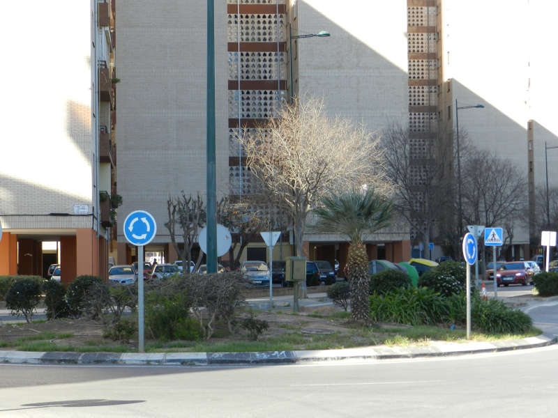 |
| 328 | watermill | Taixida Mill | This flour mill was ...This flour mill was built at the beginning of the 19th century, being its production rather scarce. It was located in the departure of Taixida, on the irrigation ditch of the same name. At the end of the 19th century it belonged to Antonio Dols, who also |  |
| 329 | watermill | Catx Mill | El conjunt edificat ...El conjunt edificat del molí està situat en la partida de Fadrell, sobre el tram nou de la séquia d'Almalafa que el travessa pel mig. La construcció és de la primera meitat del segle XIX i presenta un cos senzill a la part davantera amb una sèrie d |  |
| 330 | watermill | Babiloni Mill | The building of the ...The building of the flour mill is located in Fadrell. It was built in the first decades of the 19th century and had three floors and a gable roof. It is an elongated construction made with masonry that is located perpendicular above the layout of the irr |  |
| 331 | watermill | Ortells Mill | The mill building is ...The mill building is located in the Almalafa district, has two floors and a rectangular floor plan, with a gabled roof. The set built in the late nineteenth century is complemented by several outbuildings in the north and east. The dominant construction |  |
| 332 | watermill | Barranc Mill | The mill was built a ...The mill was built at the beginning of the 19th century in the Fadrell district, on the outlet of the new Almalafa irrigation channel that was built after the definitive division of water between Castelló and Almassora. The mill building, which was stil | 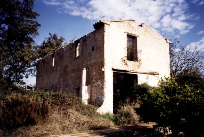 |
| 333 | swamp | Maria Cristina Swamp | The reservoir or dam ...The reservoir or dam of Maria Cristina was built on the course of the Rambla de la Viuda, a tributary of the river Millares, in the place known as the strait of the Tozal del Morral, between 1913 and 1925. In 1900 the concession was granted to Carlos Bar | 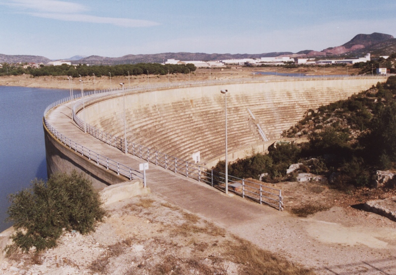 |
| 334 | swamp | Santa Quitèria Swamp | The Santa Quitèria ...The Santa Quitèria reservoir is a small reservoir built in 1983 on the Millares river with a capacity of 200,000 m³, which serves as a regulating reservoir. It is located very close to the medieval bridge that crosses the river and a little more than 4 | 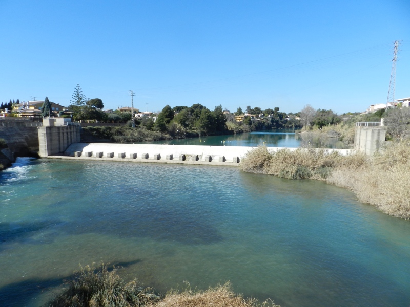 |
| 335 | partition | Former Royal Partitioners | The partition is res ...The partition is resolved with a central cutwater and lateral ashlars, with a recess to slide wooden gates. These are the old royal dividers that divided the water between the Molino irrigation channel -formerly from Almassora- and the Mayor irrigation c | 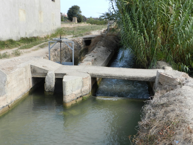 |
| 336 | partition | Major/Coscollosa Partitioner | The main irrigation ...The main irrigation ditch of Castelló had its second major diversion just beyond the walled limits of the medieval city, at its northeastern end. While the main branch slightly decreased its slope, the *Coscollosa ditch continued describing a precise ar |  |
| 337 | partition | Partidor de llengües Almalafa/Vinamargo | The partition of ton ...The partition of tongues of the ditches *Almalafa/*Vinamargo is an example of this type of construction to distribute waters that generates two new ditches. In this case, the stone partition separates the water flow of the ditch of *Almalafa in other two | 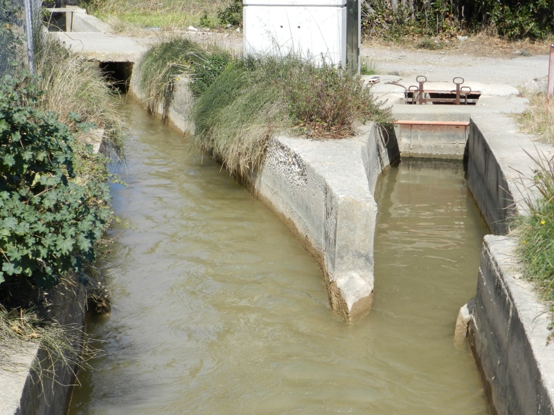 |
| 338 | partition | Almalafa/Valero Partitioner | The partidor of tong ...The partidor of tongues of the ditches Almalafa/Valero consists of a tajamar, with stone edge in the bottom and with a rounded frontal. It is located inside the new Almalafa irrigation channel, built in 1789, and distributes the water flow between the tw |  |
| 339 | partition | Mitjana Partitioner | The eye of the Media ...The eye of the Mediana ditch is a derivation practiced to the Major ditch of Castelló, by its left side, to irrigate some zones of alters and to return later to overflow the water to the mother ditch. The water diversion took advantage of the stop and r |  |
| 340 | partition | Sequiol Partitioner | The Sequiol is a sec ...The Sequiol is a secondary conduction that runs through an area of alters above the main irrigation ditch in the vicinity of the old medieval town. It derives from the mentioned main ditch at the height of the Fraga ravine and drew a slight curve to face | 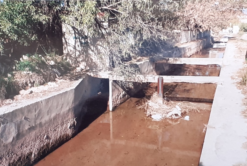 |
| 341 | canal | Mined Ditch of Castelló | The new route of the ...The new route of the Castelló irrigation ditch, which begins at the partition of the Casa de las Rejas, is a long subway gallery that comes to the surface at the height of the ravine that separates the municipalities of Almassora and Castelló. The mine |  |
| 342 | canal | Rambla de la Viuda Ditch | The boot was built s ...The boot was built so that the common ditch of Castelló/Almassora overcomes the bed of the wadi of the Widow when it connects with the river and could take the water to the left margin of the river. The subway pipe has a length of 156 m approximately an | 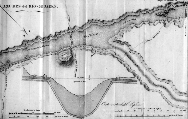 |
| 343 | canal | Ditch of the Pantà | The irrigation ditch ...The irrigation ditch of the reservoir is a hydraulic infrastructure formed by an extensive network of canals and ditches. The diversion channel was 14 kilometers long, from the dam of Maria Cristina to overcome the Torreta ravine and reach the path or pa |  |
| 344 | canal | Mercader Ditch | It is a hydraulic in ...It is a hydraulic infrastructure, built approximately between 1781-1787 by Salvador Catalán "El Mercader", a man of money and merchant of Castelló de la Plana. The project was very ambitious because he also intended to build an agricultural colony, wit |  |
| 345 | canal | Foment Ditch | The starting point o ...The starting point of this infrastructure was in 1872, when Antonio Barrachina obtained a water concession for the water flowing through the Viuda watercourse to irrigate 400 hectares of dry land in the Benadressa district. The project recovered Mercader | 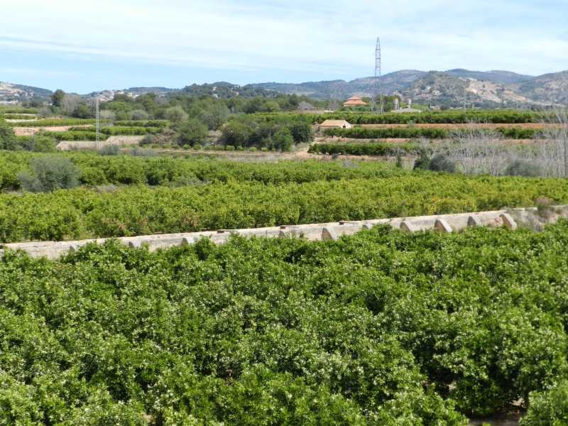 |
| 346 | canal | Major de Castelló Ditch | The origin of the Ma ...The origin of the Major irrigation channel of Castelló dates back to the Andalusian period and, therefore, prior to the foundation of Castelló in the 13th century, in the time of King Jaime I. The first main irrigation channel of Castelló had its weir | 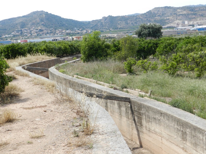 |
| 347 | chimney | Quadra de Cassanya Chimney | It is a tiled chimne ...It is a tiled chimney related to a water extraction well for irrigation located on the border of the Marrada and Estepar districts, on the edge of the Cassanya block, from the beginning of the 20th century. The motor is out of use and dismantled at the p |  |
| 348 | chimney | Pou Neptuno Chimney | It is a tiled chimne ...It is a tiled chimney related to a well of extraction of water for irrigation, property of the irrigation society "Pozo Neptuno" of Castelló, and located to the Marrada departure, bordering the Jabonero block, although nowadays it is already part of the |  |
| 349 | chimney | Censal Chimney | It is a tiled chimne ...It is a tiled chimney related to a water extraction well for irrigation located in the Censal area, between the Almassora road and the main irrigation ditch, near the old Ribelsalbes road, from the beginning of the 20th century. Associated to the chimney |  |
| 350 | chimney | Pou La Unión Chimney | It is a tiled chimne ...It is a tiled chimney related to a water extraction well for irrigation, owned by the irrigation company Unión Hidráulica and is called "Pozo la Unión". It is located at the southern end of the Estepar district, near the Almassora road and dates from | 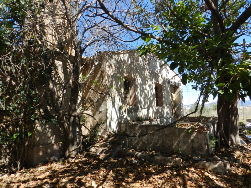 |
| 351 | chimney | Pou del Mas de Rambla Chimney | It is a chimney of t ...It is a chimney of tile related to a well of extraction of water for the irrigation located to the departure of Benadressa, edge the stable of the Negrero, of beginning of the XX century. The well is located in the farmhouse of Rambla and associated to t | 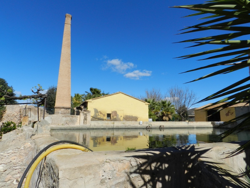 |
| 352 | water source | Fonte do Jardim | <p>Circula ... <p>Circular fountain locate in a wide main central area of Campo Maior. Is is used as an ornamental place</p> |  |
| 353 | water source | Fonte do Largo da Casa do Povo | <p style= ... <p style="text-align: justify;">Fountain of backrest type font built during the dictorial regime using simple characteristics, namely at the level of the curved stonework backrest. It has water running but it is not advisable to drink. It is dated 1954. However, it is very likely that near this location there was another source, associated with the extinct and disappeared convent of S. João de Deus, which housed the military hospital of Campo Maior, in the 17th and 18th centuries.</p><p style="text-align: justify;">A fountain can still be seen today in the courtyard leading to the house which occupies part of the land that belonged to the convent and which is located between the streets of S. João, Santa Cruz, Visconde de Seabra and Vasco Sardinha<span class="Y2IQFc" lang="en">.</span></p> | 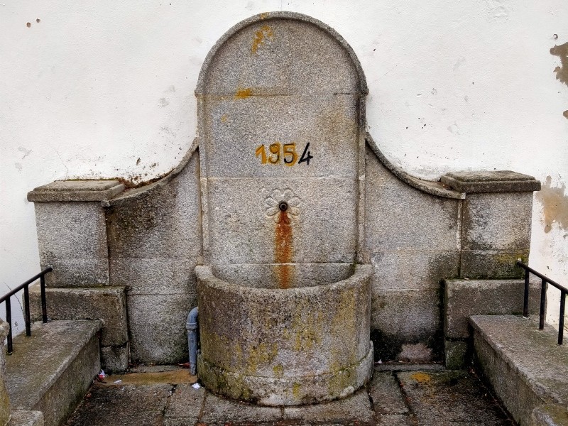 |
| 354 | water source | Fonte do Largo do Barata | < ... <p>It is a fountain placed inside the 17th century walls but, as it is located at an important entrance to the town, it had the dual function of a fountain and a drinking fountain for animal. It is not currently in use.</p> | 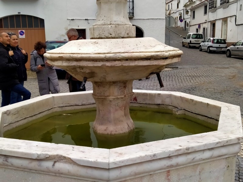 |
| 355 | water source | Fonte dos cantos de baixo | <p>It was ... <p>It was the place where the men gatheredearly in the morning to be chosen by the landowners to do some work. It is still a place for socializing. It has no running water</p> |  |
| 356 | water source | Fonte de São Francisco | <p>It's an ... <p>It's an example of Baroque architecture, built in 1766. It is located in a corner, theatrically arrengedin relation to the surrounding urban space. It was classified as a municipal interest in 2014. It has no running water. It has a decorative purpuse.</p> |  |
| 357 | water source | Chafariz da abertura | <p>Situate ... <p>Situated in Largo de Sao Francisco, this fountain was a place where animals could drink. The ramaining water was channeled behind the so-called mini aqueduct for agricultural use in the nearby lands.</p> |  |
| 358 | water source | Fonte das negras | <p>Was a p ... <p>Was a public washing tank called "Tanquinhos", witch ran till 1982. Is was closed because it was rarely used. It was also a drinking fountain for animals. The spouts of the fountain were closed at night so that the water could be enterely used in watering the crops of the near farms.</p> | 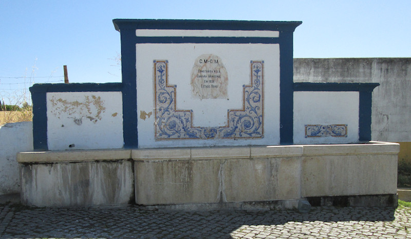 |
| 359 | water source | Fonte da Praça Velha | <p>It ... <p>It is the highest fountain in the village next to the castle and has a centralized and regular, hexagonal plan, composed of a vertical articulation. Its construction must have resulted from the need to supply water to the population of Campo Maior, which had increased substantially in modern times, leading to the construction of several fountains within the streets of the village for three centuries.</p><p>At the beginning of the 20th century, it was removed from its original location in Cantos de Baixo, to allow the circulation of buses that went to the bus station located at the time in Terreiro.</p><p class="tw-target-rmn tw-ta-container F0azHf tw-nfl" id="tw-target-rmn-container"><pre class="tw-data-placeholder tw-text-small tw-ta" data-placeholder="" id="tw-target-rmn" style="text-align:left" dir="ltr"><span class="Y2IQFc"><br></span></pre></p> |  |
| 360 | water source | Fonte Nova | < ... <p>Is a fountain with a tank made of marble and masonry backrest. It has the coat of arms of Portugal and two Manueline sphere. It has water but it isn't advisable to drink.</p><p>Located in one of the occurrences of the village of Campo Maior, next to the road that goes to the village of Degolados, Fonte Nova is a fountain of probable 16th century edification. The building, which is integrated into a wall, is divided into two parts, the lower part corresponding to the rectangular stone tank, one formed by the backrest <sub><sup><span class="EOP SCXW248637479 BCX2" style="font-size: 14pt; line-height: 24.8208px; font-family: Calibri, "Calibri_EmbeddedFont", "Calibri_MSFontService", sans-serif;" data-ccp-props="{"201341983":0,"335559740":259}">.<br></span></sup></sub></p> | 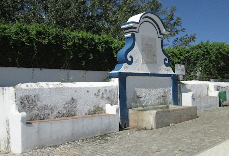 |
| 361 | aqueduct | Aqueduct of Amoreira | <p>The aqu ... <p>The aqueduct was built in order to bring water to the city that was between walls. In 1527, the spring that could feed an aqueduct was determined, the source of Amoreira.In 1537, King João II sent the architect Francisco de Arruda to design the Aqueduct.Between 1548 and 1570 the works were stopped.In 1573, D. Sebastião sent the architect Afonso de Alvares to finish the Aqueduct. Construction stops again from 1580 onwards. In 1598 King Filipe I orders construction to continue.The aqueduct was completed in 1622, when on the 23rd of June water flowed for the first time to the source of Misericórdia.</p><p> It has 7054 m from the source in Serra do Bispo to the Chafariz do Jardim, and from there to Fonte da Vila a further 450m. In underground it is 1367m, at ground level 4049 and, over arcades, 1683m. In Outeiro de São Francisco begins the second channel, which inflects towards Outeiro dos Pobres and meets the arcade in Rossio. It is launched in a total of 833 arches that at some points overlap in four registers, from perfect round stirrup arches, with shoulder pads decreasing according to the height. The arcades are supported by quadrangular pillars, strengthened by semicircular and pyramidal buttresses of different heights.</p> | 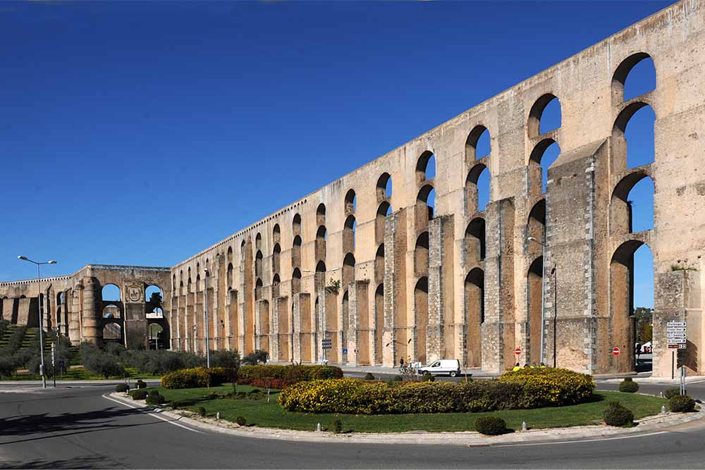 |
| 362 | reservoir | Cisterna | <p>The large c ...<p>The large cistern of Elvas was built in 1650 by Nicolau de Langres, to supply the city with water from the Amoreira Aqueduct. It was bomb proof and was considered in the 19th century. XIX by George Borrow as the largest in the world, with a capacity of 2320 m3, which allowed to supply the city during 4 months of siege. The cistern consists of a vaulted building, which is descended through a staircase of 26 steps. Down there we find three voids 58 meters long, 5 meters wide and 8 meters high. Outside there is a fountain with a tank and 4 fountains topped with marble.</p> | 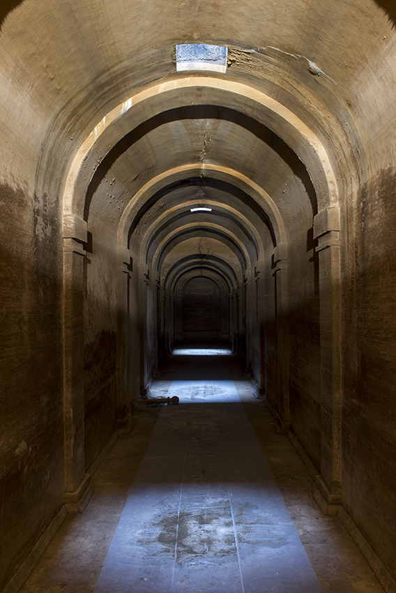 |
| 363 | water source | Fonte da Biquinha | <p class=&quo ... <p class="module--translations-translatedtext js-module--translations-translatedtext is-placeholder" data-size="s" style="height: 402px;">Also called Biquinha dos Currais in 1767 or Biquinha dos Fornos in 1810, it was built in 1654 in front of the old Assento and continues today to provide water to the population of that area of the city. It consists of a shell-shaped tank into which a small tap pours water. Interest in the fountain centers on the seventeenth-century blue and yellow tile panel it contains.</p> |  |
| 364 | water source | Fonte de São Lourenço | < ... <p class="module--translations-translatedtext js-module--translations-translatedtext is-placeholder" style="height: 717px;" data-size="s">Fountain built in the second half of the century. XVIII by Judge Bernardo Xavier de Barbosa Sachetti to the French military engineer Valleré who at the time worked on the works of the Fort of N. Sra. da Graça, in the place where there was already another Fountain of São Lourenço, this seventeenth century (1626) and which was moved to the Quinta de Sto. António on the outskirts of the city. The construction project was grandiose and expensive as Sachetti wanted, and Valleré influenced by French neoclassical art there begins to build a fountain on which to place statues of female figures of Greco-Roman mythology. The statues that would serve the fountain remained in Quinta de Sto. António. Return in 2005. The fountain consists of three spouts that make the water run to a rectangular tank, all surmounted by four columns that at its top have the said statues. Fountain composed of backrest and tank. Simple volume arranged vertically. Back-to-SO splinter, of two registers; the lower one consists of three rectangles delimited by marble friezes filled internally by rock aphorements and with water spout, in the center, with hexagonal base affixed to the backrest and circular in front where it fits metal pipe; Rectangular marble tank describing countercurved plan next to the exterior angles where are inserted, one on each side, two frames of circular base, hexagonal body and semispherical upper finish.<br></p><p class="module--translations-translatedtext js-module--translations-translatedtext is-placeholder" data-size="s" style="height: 591px;"><br></p><p class="module--translations-translatedtext js-module--translations-translatedtext is-placeholder" data-size="s" style="height: 591px;"><br></p> | 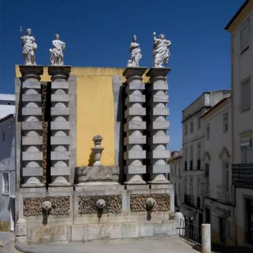 |
| 365 | water source | Fonte da Piedade | <p class="mo ...<p class="module--translations-translatedtext js-module--translations-translatedtext is-placeholder" style="height: 308px;" data-size="s">Fountain
located in front of the Piedade Park and the Church of Senhor Jesus da
Piedade. It stands out the sober style, typical of the time of
construction, and the 3 panels of blue and white tile representative of
different scenes: "Prudence", "Abundance" and "Storm", respectively. The
sink is rectangular and has two water spouts.</p> |  |
| 366 | bridge | Ponte da Ajuda | <p> ... <p>Ponte da Ajuda, also referred to as Ponte de Nossa Senhora da Ajuda and as Ponte de Olivença, is located over the Guadiana river, connecting the current Portuguese parishes from the municipality of Elvas, to the municipality of Olivença, currently under Spanish rule. In 1967 the bridge was declared a Property of Public Interest by the Portuguese state. Currently in ruins, it connected the towns of Elvas and Olivença. In 2000, a new bridge was inaugurated, a short distance and downstream of the old one, built and financed by the Portuguese government.</p><p>The bridge has 380m lenght by 5,5m wide, it was supported by 19 arches, defended by a solid turret in its center, this turret divided internally into three floors, with rooms equipped with windows. The turret was built on large boulders, which can still be seen today. It was build during Manuel I of Portugal with the function of ensuring the operation of the Portuguese military forces on the left bank of the river Guadiana, in support of the Castle of Olivença, on December 19, 1510, in the so-called place of Nossa Senhora da Ajuda (Help).</p><p>In 1597, some of the central arches collapsed as a result of heavy floods that significantly increased the flow of the Guadiana River. Later, in 1641, after several severe winters caused damage to the bridge, it was repaired by order of General D. João da Costa, who had two of the defective arches replaced by drawbridges. It was partially destroyed by the Castilian army during the War of Restoration in September 1646 and was repaired after the end of the war. Later, in 1709, in the context of the War of the Spanish Succession, the Castilian army blew up the bridge, partially destroying it again. From that time on, the connection between Elvas and Olivença had to be carried out through Spanish lands. The bridge remains in ruins from that date until today, having not undergone any restoration. </p> | 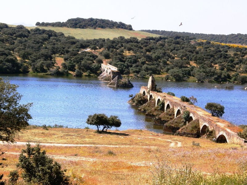 |
| 367 | water source | Fonte da Prata | <p>Located ... <p>Located outside the walls next to the Portas de São Vicente, the<strong> Fonte da Prata</strong> is a construction of the century. XVIII having as its first designation the Fonte Nova do Príncipe. The excellent quality of its waters led the people to call it the Silver. In fact, the medicinal properties of that place were already known since the Islamic occupation, because it was there that the Muslims built their baths, which lasted until quite late.The Silver Fountain was changed in 1830, the date of the current spout, and later in front of it was built a tank that the washerwomen used to use. The fountain of the fountain with 15 meters long was intended for drinking animals and on its backrest were the royal arms of the century. XVII that disappeared in the middle of the century. XX.<br></p> |  |
| 368 | water source | Fonte de Gil Vaz | <p>The Fountai ...<p>The Fountain of Gil Vaz is cited in documents since 1435 but was then located in a different place, although not far from the current one. In 1652, the Chamber of Elvas ordered to rebuild it to Domingos Pires. Because it is located in the middle of the field and is very busy, the fountain was moved to the road where it is today. The fountain that we see today on the Estrada de Gil Vaz is a work of 1791 elaborated by António dos Santos, with some improvements made in 1827. It is a small fountain that is still very busy today.<br></p> |  |
| 369 | water source | Fonte da Alameda | <p class="mo ...<p class="module--translations-translatedtext js-module--translations-translatedtext is-placeholder" data-size="s" style="height: 444px;">Built
after the inauguration of the Amoreira Aqueduct in 1622, when in the
following years several fountains were built. It was located in the old
municipal garden, called Alameda, where it remained until 1811 when it
was dismantled. In 1844 it was again mounted, but now at the entrance of
the municipal cemetery. Built in Estremoz marble in the Mannerist
style, with a wall around the hexagonal tank under which stands the
mushroom-shaped fountain with a pinnacle at the top.</p> | 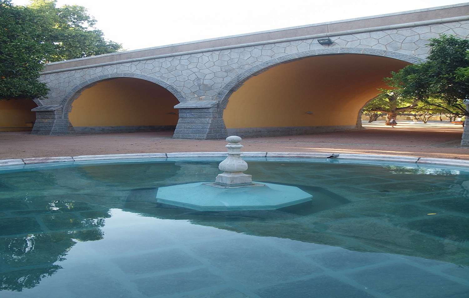 |
| 370 | reservoir | Cisterna do Forte da Nossa Senhora da Graça | <p>At the Fort ...<p>At the Forte da Nossa da Graça it houses an underground cistern, with a large storage capacity and which received water from the embankment, moat and terraces of the roofs of the redoubt and the governor's house, having rectangular compartments, covered by a barrel vault, the main ones of the cross having in the center, octagonal, a pillar supporting turning vault<br></p> | 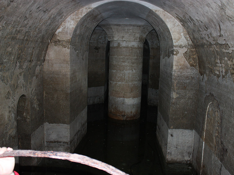 |
| 371 | water source | Fonte da Misericórdia | <p>The Fon ... <p>The Fonte da Misericórdia was built in 1622 under the design of the architect of the Royal House, Diogo Marques, in Largo da Misericórdia in works inspected by the architect of the House of Bragança Pêro Vaz Pereira so that the first waters of the Amoreira Aqueduct flowed there.</p><p>1622, 23 June - water flows for the first time in the fountain, in Largo da Misericórdia, made by mason Sebastião Vaz, according to a design by Diogo Marques and inspected by Pêro Vaz Pereira; In 1951, the alteration project in that area of the city caused the fountain to be transferred to the current Largo 25 de Abril because it seemed to congest traffic in Largo da Misericórdia. Is built in marble from Estremoz ( a region rich in marble). In the center of the fountain is an equestrian statue of D. Sancho II (dressed in armor holding a shield in his left hand with Quinas). The dolphin-shaped spouts gush water into a three-lobed tank where one of the stones bears the inscription “1622 ANOS”.</p><p>The set is surrounded by an iron railing with a marble base interrupted by three pairs of balusters in the form of volutes that allow access to the tank and three balusters in the form of fireworks arranged in a triangle.</p> | .jpg) |
| 372 | water source | Fonte de São Vicente | <p>A 17th-cent ...<p>A 17th-century fountain, namely from 1628, it is one of the three fountains that were built to serve the population with water from the Amoreira Aqueduct.</p><p>The fountain of São Vicente follows a Mannerist style, in which it is elaborated by a wall around the fountain, all of it built in marble from Estremoz.</p><p>With a hexagonal plan accompanying the tank with the same plan, the fountain follows the shape of a mushroom and ends with a pinnacle.<br></p> |  |
| 373 | water source | Fonte da Fé no Santuário do Senhor Jesus da Piedade | <p>Built into ...<p>Built into the back of the Santuário do Senhor Jesus da Piedade is a beautiful marble piece framed by 19th-century tiles.</p><p>The tiles cover the inside of the arch of the fountain, forming the background for a naturalist sculptural set that represents two children wrapped in shells holding a frown. They are supported by two fish.</p> |  |
| 374 | water source | Fonte parque da Piedade | < ... <p class="module--translations-translatedtext js-module--translations-translatedtext is-placeholder" data-size="s" style="height: 276px;">Ordered to be erected by D. Ana Silva de Matos in 1881 as a thank you
for restoring her sketch. It is topped by a statue of faith on a
rectangular pedestal.</p> | 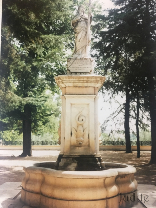 |
| 376 | water well | Poço de Alcalá | <p> ... <p><span id="docs-internal-guid-400470b6-7fff-7f05-3047-be4c1a4fb28e"><span style="font-size: 11pt; font-family: Arial; color: rgb(255, 0, 0); font-variant-numeric: normal; font-variant-east-asian: normal; vertical-align: baseline; white-space: pre-wrap;">Alcalá, built by the Arabs between the 8th and 11th centuries.</span></span><br></p> |  |
| 377 | water source | Chafariz d’El Rey | <p cl ... <p class="MsoNormal" style="text-align:justify"><span style="font-family: Arial, "sans-serif"; font-size: 16px;">Grandiose fountain located at the beginning of the Amoreira Aqueduct through which its waters gushed. Its construction also ended in 1656 and is made up of three masonry bodies topped by volutes with the 17th-century coat of arms of Portugal in marble in the central part.</span><br></p> |  |
| 378 | water source | Chafariz do Aqueduto | <p>The Fou ... <p>The Fountain of "<strong>Nossa Senhora da Nazaré"</strong> located at the end of the
Amoreira Aqueduct through which its waters flowed. Its construction ends
in 1622 and consists of two bodies in masonry surmounted by volutes
having, at the time of its construction, in the central part the
seventeenth-century arms of Portugal in marble. It consists of a
rectangular tank and has always served those who devoutly went to the
Chapel of Our Lady of Nazareth. </p> | 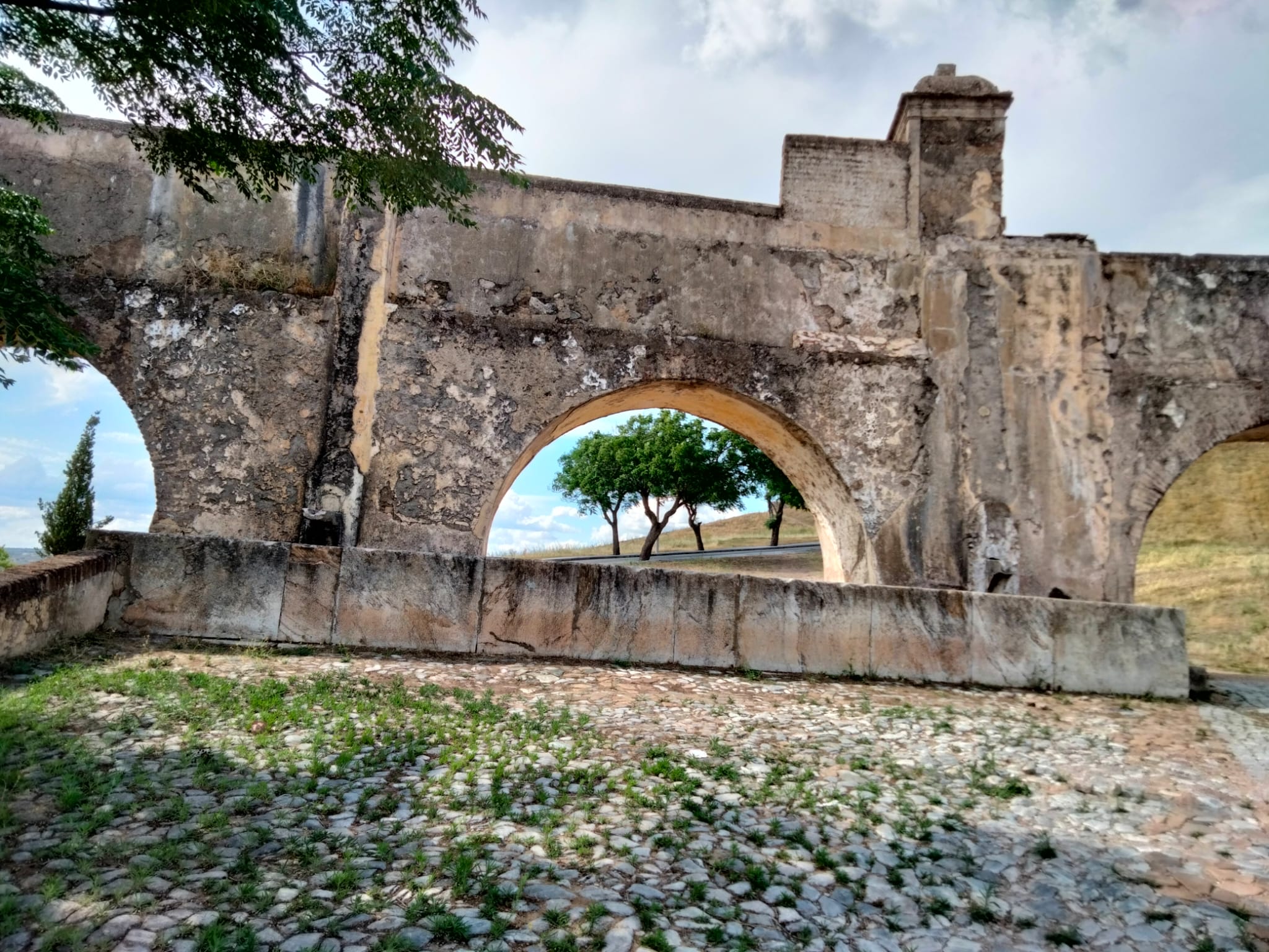 |
| 379 | spring | Font de ls Solsida | <p>Fuente natu ...<p>Fuente natural ubicada en la ladera norte del Puig Campana, junto a una pared casi vertical. En época de lluvias suele llevar agua. En la actualidad (febrero 2024) está seca. Está en plena ruta de senderismo PR CV-289 que redea todo el conjunto del Puig Campana. Está muy transitada por senderistas, a pesar de su dureza, y es uno de los destinos favoritos de las rutas de mountain bike más exigentes. Muy próximo a ella se encuentra el desvio que nos lleva a la cima del Puig Campana (1408 m), y su gemelo el Pic Prim (1344 m). La ruta disponde de excelentes vistas en todo su recorrido.</p><p><br></p> | 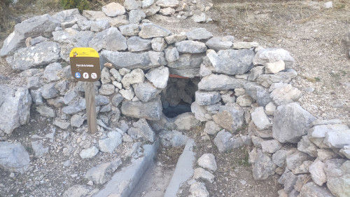 |
| 380 | water well | Fuente de la Amapola | <p>Sencilla pe ...<p>Sencilla pero hermosa fuente que podemos encontrar en el conocido barrio del Sacromonte, próximo a las casas-cueva, y muy próximo se encuentra el final de la muralla medieval.</p><p>El nombre de la fuente aparece en un recuadro cerámico, así como el verso con este contenido "Cuanto me gustaría ser la fuente de mi barrio pa cuando pases y bebas sentir muy de cerca tus labios"</p> | 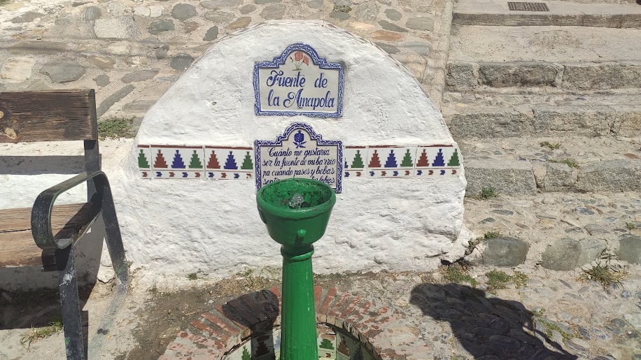 |